|
search place name
|
||
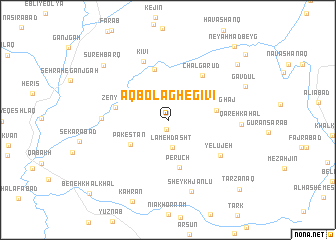
Āqbolāgh-e Gīvī (Ardabīl, Iran)Āqbolāgh-e Gīvī is a town in the Ardabīl region of Iran. An overview map of the region around Āqbolāgh-e Gīvī is displayed below.
regional and 3d topo map of Āqbolāgh-e Gīvī, Iran ::
Āqbolāgh-e Gīvī airports ::
The nearest airport is RAS - Rasht, located 115.1 km east of Āqbolāgh-e Gīvī.
Nearby towns ::
Behestān (1.0km south) //
Lam‘eh Dasht (3.1km south) //
Pākestān (4.4km south west) //
Qareh Āghāj (4.4km east) //
Perūch (5.4km south) //
Kīvī-ye Pā'īn (5.8km north) //
Zenyāb (4.8km west) //
Chālgarūd (5.9km north east) //
Yelūjeh (6.1km south east) //
Kīvī (6.9km north) //
Sa‘īdābād (5.9km west) //
Qareh Kahal (6.5km east) //
Sheykh Jānlū (8.2km south) //
Gāvdūl (7.8km north east) //
Sūreh Barq (8.3km north west) //
Āb-e Garm (8.7km north east) //
Īstī Sū (8.7km north east) //
Ney Aḩmad Beyg (10.1km north east) //
Tarzanaq (10.1km south east) //
Gol Tappeh (10.0km north east) //
Beneh Khalkhāl (10.7km south west) //
[all distances 'as the bird flies' and approximate]  Places with similar names to Āqbolāgh-e Gīvī, Iran :: Disclaimer :: Information on this page comes without warranty of any kind |
||
|
Where is Āqbolāgh-e Gīvī? Elevation and coordinates ::
Latitude (lat): 37°37'39"N Longitude (lon): 48°21'39"E
Elevation (approx.): 1663m (map arrows pan, magnifying glasses zoom) |
||
|
Visiting Āqbolāgh-e Gīvī? Hotel/Accommodation ::
Book a hotel in Āqbolāgh-e Gīvī Travel Guide ::
Buy a travel guide for Iran rental cars ::
car rental offers GPS waypoint ::
download a GPX waypoint (PoI) of Āqbolāgh-e Gīvī for your GPS receiver
|
||