|
search place name
|
||
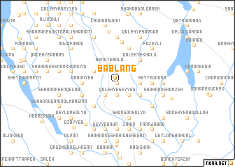
Bāb Lang (Khūzestān, Iran)Bāb Lang is a town in the Khūzestān region of Iran. An overview map of the region around Bāb Lang is displayed below.
regional and 3d topo map of Bāb Lang, Iran ::
Bāb Lang airports ::
The nearest airport is QMJ - Masjed Soleiman Shahid Asyaee, located 75.9 km east of Bāb Lang.
Other airports nearby include AWZ - Ahwaz (98.8 km south), MRX - Bandar Mahshahr Mahshahr (192.5 km south), BSR - Basrah Intl (199.6 km south west), ABD - Abadan (204.4 km south), Nearby towns ::
Shahrak-e Qods (0.0km north) //
Shahrak-e Seyyed ‘Enāyat (0.0km north) //
Bayātīyūn-e Āşef Khān (1.9km north) //
Qal‘eh-ye Seyyed (1.9km south) //
Benūt-e Pāʼīn (2.4km north west) //
Belādīyeh (2.4km south east) //
Āb-e Gheyrūb (2.4km south west) //
Benūt-e Bālā (3.1km north) //
Seyyed Mehdī (3.1km east) //
Emāmzādeh Edrīsī (3.1km east) //
Bayātīān-e Aşef Khān (3.6km north west) //
Boneh-ye ‘Īsá (3.6km south east) //
Mobārezābād (3.6km south east) //
Qal‘eh-ye Khalīl (4.9km north east) //
Sālārābād (4.9km south west) //
Choghā Mīsh (4.7km east) //
Seyyed Mūsá (4.7km east) //
Raḩīmīyeh (4.7km west) //
Boneh-ye Raḩīmeh (5.1km west) //
Shalgehī-ye Pā'īn (5.8km north) //
Shahrak-e Kheybar (5.8km south) //
Shongor-e ‘Olyā (5.8km south) //
Sangar-e ‘Olyā (5.8km south) //
Shahrak-e Shahīd Karīmī (6.6km north) //
Shahrak-e Nehẕat (6.0km south east) //
Choghā Mīsheh-ye Dowlatī (6.3km east) //
Shalgahī-ye Pāʼīn (7.4km north) //
Shahrak-e Seyyed Nūr (7.4km south) //
Bayātīyūn-e Arshad (6.5km west) //
[all distances 'as the bird flies' and approximate]  Places with similar names to Bāb Lang, Iran ::
// Babalanga (PH)
// Bąblinek (PL)
// Bąbliniec (PL)
// Bābā Lang (IR)
// Bābā Lang (IR)
// Babah Lueng (ID)
// Babalang (ID)
// Babuhlueng (ID)
// Bubalango (ID)
// Bubalango (ID)
Disclaimer :: Information on this page comes without warranty of any kind |
||
|
Where is Bāb Lang? Elevation and coordinates ::
Latitude (lat): 32°12'0"N Longitude (lon): 48°30'0"E
Elevation (approx.): 76m (map arrows pan, magnifying glasses zoom) |
||
|
Visiting Bāb Lang? Hotel/Accommodation ::
Book a hotel in Bāb Lang Travel Guide ::
Buy a travel guide for Iran rental cars ::
car rental offers GPS waypoint ::
download a GPX waypoint (PoI) of Bāb Lang for your GPS receiver
|
||