|
search place name
|
||
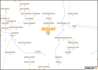
Bondar (Iran)Bondar is a town in Iran. An overview map of the region around Bondar is displayed below.
regional and 3d topo map of Bondar, Iran ::
Bondar airports ::
The nearest airport is KER - Kerman, located 133.1 km south east of Bondar.
Nearby towns ::
Shūrk-e Mīān (3.7km north) //
‘Alīābād (3.7km south east) //
Shūrk-e Pā'īn (5.2km north) //
Khūnū (5.6km north) //
Ma‘dan-e Sorb-e Ţarz (5.1km east) //
Kārgāh-e Felezzāte-e Yazd (5.1km east) //
Shūrak-e ‘Olyā (6.0km north east) //
Deh-e Āqā Reẕā (7.4km north) //
Darshūr-e Bālā (6.6km east) //
Āb Korū'īyeh (6.6km east) //
Estāj (8.0km south west) //
Deh-e Jabbār (7.3km north west) //
Deymeskān (7.3km east) //
Deh Chenārū'īyeh (8.4km south east) //
Solţānābād (8.8km north west) //
Mīr Khān (8.8km north west) //
Gāz Kahan (8.8km north west) //
Deh Now-e Seyyedābād (8.8km north west) //
Ḩasanābād (8.4km north west) //
Kotī Shūr (8.4km north west) //
Fūz (8.9km south east) //
Dar Āb (9.7km south east) //
[all distances 'as the bird flies' and approximate] 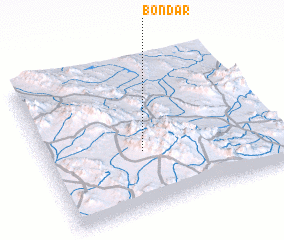 Places with similar names to Bondar, Iran ::
// Beni Idder (MA)
// Beni Idir (MA)
// Beni Idir (MA)
// Bou Antar (MA)
// Boû Ouentere (MA)
// Bandīra (ET)
// Bander (ET)
// Bañadero (PH)
// Bañadero (PH)
// Bañadero (PH)
Disclaimer :: Information on this page comes without warranty of any kind |
||
|
Where is Bondar? Elevation and coordinates ::
Latitude (lat): 31°23'0"N Longitude (lon): 56°25'0"E
Elevation (approx.): 2195m (map arrows pan, magnifying glasses zoom) |
||
|
Visiting Bondar? Hotel/Accommodation ::
Book a hotel in Bondar Travel Guide ::
Buy a travel guide for Iran rental cars ::
car rental offers GPS waypoint ::
download a GPX waypoint (PoI) of Bondar for your GPS receiver
|
||