|
search place name
|
||
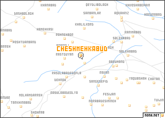
Cheshmeh Kabūd (Hamadān, Iran)Cheshmeh Kabūd is a town in the Hamadān region of Iran. An overview map of the region around Cheshmeh Kabūd is displayed below.
regional and 3d topo map of Cheshmeh Kabūd, Iran ::
Cheshmeh Kabūd airports ::
The nearest airport is KSH - Bakhtaran Shahid Ashrafi Esfahani, located 118.6 km south west of Cheshmeh Kabūd.
Other airports nearby include SDG - Sanandaj (119.3 km west), Nearby towns ::
Gondehjīn (1.1km south) //
Rāstgūyān (3.4km west) //
Āb Bārīk (4.1km south) //
Qeshlāq (4.3km north west) //
Akhtāchī (3.9km west) //
Gomūsh Bolāgh (4.0km north east) //
Bābā ‘Alī (4.3km north west) //
Rasūlābād-e Soflá (5.0km south west) //
Pahneh Bor (5.7km north west) //
Ravān (5.7km south east) //
Khalīl Kord (7.0km north) //
Sang-e Sefīd (6.7km south east) //
Tāzeh Kand (6.0km east) //
Deh Now (7.0km south west) //
Ābrūmand (6.6km east) //
Mālek-e Ashtar (7.1km north east) //
Chowtāsh (8.8km south) //
Sīmīn-e Zāgheh (7.7km south east) //
Rasūlābād-e ‘Olyā (9.2km south) //
Şāleḩābād (8.2km north east) //
Robāţ-e Za‘farānī (9.0km south east) //
Hameh Kasī (9.1km north west) //
Fesījān (10.2km south east) //
Āghcheh Kharābeh (11.4km north east) //
[all distances 'as the bird flies' and approximate] 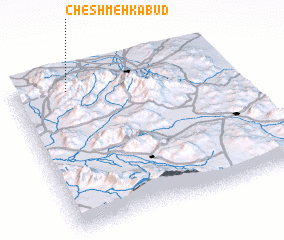 Places with similar names to Cheshmeh Kabūd, Iran ::
// Cheshmeh Kabūd (IR)
// Cheshmeh Kabūd (IR)
// Cheshmeh Kabūd (IR)
// Cheshmeh Kabūd (IR)
// Cheshmeh Kabūd (IR)
// Cheshmeh Kabūd (IR)
// Cheshmeh Kabūd (IR)
// Cheshmeh Kabūd (IR)
// Cheshmeh Kabūd (IR)
// Cheshmeh Kabūd (IR)
Disclaimer :: Information on this page comes without warranty of any kind |
||
|
Where is Cheshmeh Kabūd? Elevation and coordinates ::
Latitude (lat): 34°54'54"N Longitude (lon): 48°15'13"E
Elevation (approx.): 1897m (map arrows pan, magnifying glasses zoom) |
||
|
Visiting Cheshmeh Kabūd? Hotel/Accommodation ::
Book a hotel in Cheshmeh Kabūd Travel Guide ::
Buy a travel guide for Iran rental cars ::
car rental offers GPS waypoint ::
download a GPX waypoint (PoI) of Cheshmeh Kabūd for your GPS receiver
|
||