|
search place name
|
||
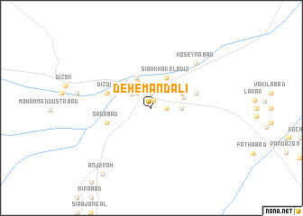
Deh-e Mandālī (Sīstān va Balūchestān, Iran)Deh-e Mandālī is a town in the Sīstān va Balūchestān region of Iran. An overview map of the region around Deh-e Mandālī is displayed below.
regional and 3d topo map of Deh-e Mandālī, Iran ::
Deh-e Mandālī airports ::
The nearest airport is ZAH - Zahedan Intl, located 74.4 km north west of Deh-e Mandālī.
Nearby towns ::
Lādīz (1.0km north) //
Mehrābād (1.9km north) //
Moḩammadābād-e Sūrān (1.6km east) //
Kalāteh (1.9km north) //
Kohneh Shūr-e Qadīm (2.5km north west) //
Reẕvān (2.5km north west) //
‘Ālam Jahān (2.8km north west) //
Āl Khān (3.2km east) //
Barzīār (3.6km north west) //
Bangān (4.0km north west) //
Kallek (4.0km north west) //
Tah Rūd (3.7km north east) //
Nowzīār (4.0km north east) //
Sīāh Khāk-e Lādīz (4.0km north east) //
Mīr Kūh (3.7km east) //
Sa‘dābād (5.2km west) //
Dīzūk (5.2km west) //
Mīr Kūh-e Bālā (5.2km east) //
Ḩoseynābād (7.4km north east) //
Anjerah (9.7km south west) //
[all distances 'as the bird flies' and approximate] 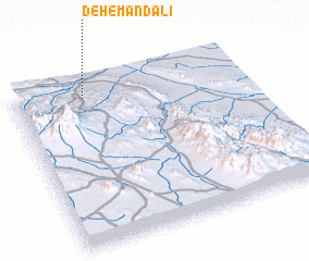 Places with similar names to Deh-e Mandālī, Iran :: Disclaimer :: Information on this page comes without warranty of any kind |
||
|
Where is Deh-e Mandālī? Elevation and coordinates ::
Latitude (lat): 28°54'0"N Longitude (lon): 61°18'0"E
Elevation (approx.): 1213m (map arrows pan, magnifying glasses zoom) |
||
|
Visiting Deh-e Mandālī? Hotel/Accommodation ::
Book a hotel in Deh-e Mandālī Travel Guide ::
Buy a travel guide for Iran rental cars ::
car rental offers GPS waypoint ::
download a GPX waypoint (PoI) of Deh-e Mandālī for your GPS receiver
|
||