|
search place name
|
||
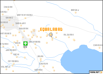
Eqbālābād (Fārs, Iran)Eqbālābād is a town in the Fārs region of Iran. An overview map of the region around Eqbālābād is displayed below.
regional and 3d topo map of Eqbālābād, Iran ::
Eqbālābād airports ::
The nearest airport is SYZ - Shiraz Shahid Dastghaib Intl, located 8.6 km west of Eqbālābād.
Other airports nearby include BUZ - Bushehr (191.5 km west), Nearby towns ::
Morghān (0.3km south east) //
Shamsābād (0.9km south) //
‘Alīābād (1.6km north) //
Kharchūl (1.5km east) //
Fīrūzān (1.5km north west) //
Kūshkak (1.6km west) //
Kaftarak (2.3km north east) //
Gol Khūn (2.6km south west) //
Qal‘eh Now (3.5km west) //
Naşrābād (3.9km north west) //
Dast-e Kheẕr (4.6km north west) //
Torkān (4.6km west) //
Nīlgūnak (5.5km east) //
Qaşr-e Shahrīār (5.7km west) //
Vazīrābād (5.8km south west) //
Qaşr-e Abū Naşr (5.9km west) //
Rovānī (6.2km south west) //
Goshnekān (6.1km north west) //
Ḩoseynābād (6.2km north west) //
Sahlābād (6.2km west) //
Sharīfābād (6.6km west) //
Aḩmadābād-e Şoghād (6.8km west) //
Qal'eh-ye Gūlīā Sefīd (7.2km east) //
Bādūnak (7.3km east) //
Āb Javār (7.3km west) //
Bīdak (8.5km south west) //
Pol-e Fasā (9.2km south) //
Bardej (11.6km north east) //
[all distances 'as the bird flies' and approximate] 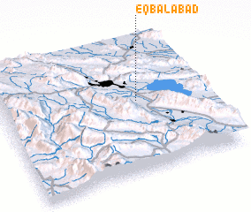 Places with similar names to Eqbālābād, Iran ::
// Eqbālābād (IR)
Disclaimer :: Information on this page comes without warranty of any kind |
||
|
Where is Eqbālābād? Elevation and coordinates ::
Latitude (lat): 29°33'37"N Longitude (lon): 52°40'31"E
Elevation (approx.): 1476m (map arrows pan, magnifying glasses zoom) |
||
|
Visiting Eqbālābād? Hotel/Accommodation ::
Book a hotel in Eqbālābād Travel Guide ::
Buy a travel guide for Iran rental cars ::
car rental offers GPS waypoint ::
download a GPX waypoint (PoI) of Eqbālābād for your GPS receiver
|
||