|
search place name
|
||
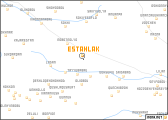
Estahlak (Iran)Estahlak is a town in Iran. An overview map of the region around Estahlak is displayed below.
regional and 3d topo map of Estahlak, Iran ::
Estahlak airports ::
The nearest airport is QMJ - Masjed Soleiman Shahid Asyaee, located 196.5 km south of Estahlak.
Other airports nearby include THR - Teheran Mehrabad Intl (258.9 km north east), Nearby towns ::
Robāţ (1.9km north) //
Robāţ-e Soflá (2.2km north) //
Ţayyebābād (3.4km south) //
Chahārţāq (3.8km south) //
Khānābād (4.4km south west) //
Robāţ-e ‘Olyā (4.7km north west) //
‘Alīābād (5.5km south) //
Deh Sefīd (5.6km south east) //
Lagān (6.3km west) //
Qeshlāq-e Sādāt (8.1km south west) //
Sakhi (8.2km north west) //
Sākī-ye Soflá (8.5km north) //
Qal'eh-ye Sībak (7.9km south east) //
Sa‘īdābād (8.2km south east) //
Qeshlāq-e Moḩammad (8.5km south west) //
Ḩoseynābād (9.6km south east) //
Qūrchī Bāshī (9.5km south east) //
Kamānkesh (10.4km south west) //
[all distances 'as the bird flies' and approximate] 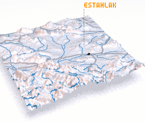 Places with similar names to Estahlak, Iran ::
Disclaimer :: Information on this page comes without warranty of any kind |
||
|
Where is Estahlak? Elevation and coordinates ::
Latitude (lat): 33°42'58"N Longitude (lon): 49°48'14"E
Elevation (approx.): 2085m (map arrows pan, magnifying glasses zoom) |
||
|
Visiting Estahlak? Hotel/Accommodation ::
Book a hotel in Estahlak Travel Guide ::
Buy a travel guide for Iran rental cars ::
car rental offers GPS waypoint ::
download a GPX waypoint (PoI) of Estahlak for your GPS receiver
|
||