|
search place name
|
||
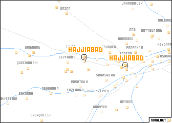
Ḩajjīābād (Markaz, Iran)Ḩajjīābād is a town in the Markaz region of Iran. An overview map of the region around Ḩajjīābād is displayed below.
regional and 3d topo map of Ḩajjīābād, Iran ::
Ḩajjīābād airports ::
The nearest airport is QMJ - Masjed Soleiman Shahid Asyaee, located 196.3 km south of Ḩajjīābād.
Nearby towns ::
Tahyaq (0.3km west) //
Kandhā (1.3km north west) //
Moḩammadābād (1.7km south) //
Dāvūdābād (2.0km east) //
Feyẕī Ḩasan (2.8km south east) //
Līlān (3.4km north west) //
Herānkeleh (3.5km south west) //
Seyfābād (3.3km west) //
Mazra‘eh-ye Ḩoseyn Soflá (3.8km south west) //
Dānīān (4.0km east) //
Khar Afkaleh (4.3km south west) //
Mībarān (4.4km east) //
‘Āshoqeh (4.7km north east) //
Poshtkūh (5.6km south) //
Shamsābād (5.5km south east) //
Būākā (5.9km east) //
Gūsheh-ye Moḩammad Mālek (7.3km south) //
Fazlābād (7.6km south) //
Kūkah (6.6km east) //
Ḩeshmatīyeh (7.9km south) //
Bīlāq (7.8km south) //
Reyḩān-e Pā'īn (7.5km south east) //
Reyḩān-e Bālā (7.5km south east) //
Esfanjeh (7.0km east) //
Sar Ţāq (7.4km east) //
Fīrūzābād (7.7km south east) //
‘Abbāsābād (7.6km east) //
Ḩājjīābād (7.6km east) //
Amirābād (8.3km north east) //
[all distances 'as the bird flies' and approximate] 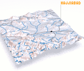 Places with similar names to Ḩajjīābād, Iran ::
Disclaimer :: Information on this page comes without warranty of any kind |
||
|
Where is Ḩajjīābād? Elevation and coordinates ::
Latitude (lat): 33°39'57"N Longitude (lon): 49°59'12"E
Elevation (approx.): 1859m (map arrows pan, magnifying glasses zoom) |
||
|
Visiting Ḩajjīābād? Hotel/Accommodation ::
Book a hotel in Ḩajjīābād Travel Guide ::
Buy a travel guide for Iran rental cars ::
car rental offers GPS waypoint ::
download a GPX waypoint (PoI) of Ḩajjīābād for your GPS receiver
|
||