|
search place name
|
||
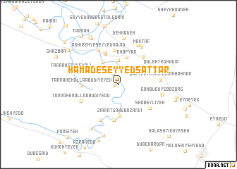
Ḩamād-e Seyyed Sattār (Khūzestān, Iran)Ḩamād-e Seyyed Sattār is a town in the Khūzestān region of Iran. An overview map of the region around Ḩamād-e Seyyed Sattār is displayed below.
regional and 3d topo map of Ḩamād-e Seyyed Sattār, Iran ::
Ḩamād-e Seyyed Sattār airports ::
The nearest airport is AWZ - Ahwaz, located 30.0 km east of Ḩamād-e Seyyed Sattār.
Other airports nearby include QMJ - Masjed Soleiman Shahid Asyaee (102.1 km north east), MRX - Bandar Mahshahr Mahshahr (114.9 km south east), ABD - Abadan (116.2 km south), BSR - Basrah Intl (121.1 km south west), Nearby towns ::
Sedreh-ye Yek (0.5km west) //
Seyyed Ya‘qūb (1.8km north west) //
Seyyed Ghīās̄ (3.8km north) //
Şadreh-ye Do (4.2km north west) //
Ghofyān (4.5km north) //
Zīāratgāh-e Bāzarvī (5.0km south) //
Rashk (5.1km north) //
Sayyed Jaber (5.5km north) //
‘Ashīreh-ye Qazbān (5.4km north) //
Ḩorījeh (5.7km south) //
Ţarrāḩ-e Mollā ‘Abūdī-ye Yek (5.0km west) //
Ghofeyleh (5.5km north east) //
Shobeylīyeh (5.6km south east) //
‘Ashīreh-ye Seyyed Majīd (6.0km north west) //
Shartāq-e Yek (6.2km south west) //
Ţarrāḩ-e Mollā ‘Abūdī-ye Do (5.7km south west) //
Qaryeh-ye Sheshom-e Bahman (5.7km east) //
Māhūr (6.8km north east) //
Maktāf (6.7km north east) //
Gambū‘eh-ye Bozorg (6.1km east) //
Qal‘eh-ye Ghadīr (6.3km north east) //
Dehkadeh (7.4km north) //
Ţarraḩ Seyyed ‘Alī (6.8km west) //
‘Abbās-e Yālīs (7.9km south west) //
Shartāq-e Do (8.4km south) //
‘Ashīreh-ye Ḩalāf (8.2km north west) //
Shobeysheh (8.5km north west) //
Azrak (9.2km south) //
Kūt (8.7km north west) //
[all distances 'as the bird flies' and approximate]  Places with similar names to Ḩamād-e Seyyed Sattār, Iran :: Disclaimer :: Information on this page comes without warranty of any kind |
||
|
Where is Ḩamād-e Seyyed Sattār? Elevation and coordinates ::
Latitude (lat): 31°24'3"N Longitude (lon): 48°27'19"E
Elevation (approx.): 20m (map arrows pan, magnifying glasses zoom) |
||
|
Visiting Ḩamād-e Seyyed Sattār? Hotel/Accommodation ::
Book a hotel in Ḩamād-e Seyyed Sattār Travel Guide ::
Buy a travel guide for Iran rental cars ::
car rental offers GPS waypoint ::
download a GPX waypoint (PoI) of Ḩamād-e Seyyed Sattār for your GPS receiver
|
||