|
search place name
|
||
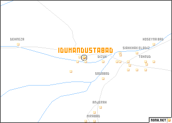
‘Īdū Man Dūstābād (Sīstān va Balūchestān, Iran)‘Īdū Man Dūstābād is a town in the Sīstān va Balūchestān region of Iran. An overview map of the region around ‘Īdū Man Dūstābād is displayed below.
regional and 3d topo map of ‘Īdū Man Dūstābād, Iran ::
‘Īdū Man Dūstābād airports ::
The nearest airport is ZAH - Zahedan Intl, located 68.9 km north west of ‘Īdū Man Dūstābād.
Nearby towns ::
Sar Rīg (0.0km north) //
‘Īdūābād (0.0km north) //
Dīzok (1.5km north west) //
Gharībābād (1.6km west) //
Parvīz (1.6km west) //
Tavakkolābād (1.6km west) //
Dīzūk (3.2km east) //
Moḩammad Dūstābād (3.6km south west) //
Sa‘dābād (4.9km south east) //
‘Ālam Jahān (5.9km east) //
Kohneh Shūr-e Qadīm (6.5km east) //
Reẕvān (6.5km east) //
Barzīār (6.7km east) //
Kallek (6.7km east) //
Bangān (6.7km east) //
[all distances 'as the bird flies' and approximate] 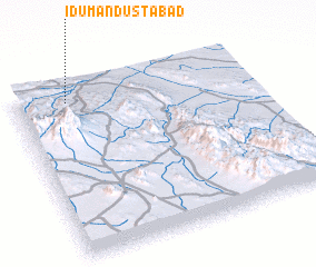 Places with similar names to ‘Īdū Man Dūstābād, Iran :: Disclaimer :: Information on this page comes without warranty of any kind |
||
|
Where is ‘Īdū Man Dūstābād? Elevation and coordinates ::
Latitude (lat): 28°55'0"N Longitude (lon): 61°13'0"E
Elevation (approx.): 1306m (map arrows pan, magnifying glasses zoom) |
||
|
Visiting ‘Īdū Man Dūstābād? Hotel/Accommodation ::
Book a hotel in ‘Īdū Man Dūstābād Travel Guide ::
Buy a travel guide for Iran rental cars ::
car rental offers GPS waypoint ::
download a GPX waypoint (PoI) of ‘Īdū Man Dūstābād for your GPS receiver
|
||