|
search place name
|
||
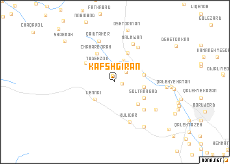
Kafshgīrān (Lorestān, Iran)Kafshgīrān is a town in the Lorestān region of Iran. An overview map of the region around Kafshgīrān is displayed below.
regional and 3d topo map of Kafshgīrān, Iran ::
Kafshgīrān airports ::
The nearest airport is KSH - Bakhtaran Shahid Ashrafi Esfahani, located 142.5 km west of Kafshgīrān.
Other airports nearby include SDG - Sanandaj (207.1 km north west), QMJ - Masjed Soleiman Shahid Asyaee (223.3 km south), Nearby towns ::
Barakatābād (1.0km east) //
Kheshtīānak (2.3km north east) //
Amīrābād-e Gūdarzī (3.0km north) //
Bondīzeh (3.7km north) //
Tūdeh Zan (3.6km north west) //
Vennā'ī (4.0km south west) //
Sheykh Mīrī-ye Sādāt (4.0km east) //
Karkī Khān (4.1km east) //
Oshtorīnān (5.0km north) //
Kapargah (4.8km south east) //
Solţānābād (4.8km south east) //
Chahār Borah (5.2km north west) //
Majīdābād (4.9km north west) //
Amīrābād (6.0km south east) //
Gol Chehrān (6.4km north east) //
Malmījān (6.6km north) //
Kūlīdar (6.8km south) //
Qāʼīd Ţāher (7.0km north) //
Sheykh Mīrī-ye Kalhor (7.1km south east) //
Amīrīyeh (7.1km east) //
Sarāb-e Panbeh (8.3km south east) //
Oshtorīnān (8.6km north) //
Shab Māh (9.5km north west) //
Ḩājjīābād-e Zereshkeh (10.7km south east) //
[all distances 'as the bird flies' and approximate]  Places with similar names to Kafshgīrān, Iran :: Disclaimer :: Information on this page comes without warranty of any kind |
||
|
Where is Kafshgīrān? Elevation and coordinates ::
Latitude (lat): 33°56'26"N Longitude (lon): 48°37'26"E
Elevation (approx.): 1755m (map arrows pan, magnifying glasses zoom) |
||
|
Visiting Kafshgīrān? Hotel/Accommodation ::
Book a hotel in Kafshgīrān Travel Guide ::
Buy a travel guide for Iran rental cars ::
car rental offers GPS waypoint ::
download a GPX waypoint (PoI) of Kafshgīrān for your GPS receiver
|
||