|
search place name
|
||
Khāneh-ye Īrān (Iran)Khāneh-ye Īrān is a town in Iran. An overview map of the region around Khāneh-ye Īrān is displayed below.
regional and 3d topo map of Khāneh-ye Īrān, Iran ::

Khāneh-ye Īrān airports ::
The nearest airport is RAS - Rasht, located 119.1 km north east of Khāneh-ye Īrān.
Other airports nearby include SDG - Sanandaj (209.5 km south west), Nearby towns ::
Noqţeh Bandī (2.4km south west) //
Sherkat-e Īrān Tarāns Fow (2.4km north west) //
Sāyān (3.0km west) //
Kharāb Ākh (3.0km west) //
Zarqān (3.0km west) //
Dīzajābād (3.4km east) //
Ḩasan ‘Abdāl (4.8km south west) //
Kol Bolāgh (5.8km north) //
Qīāsābād (5.8km north) //
Gol Bāgh (6.3km north east) //
Chūreh Nāb (7.4km north) //
Do Asb (7.6km north) //
Qareh Tappeh (7.0km south west) //
Būlāmājeh (8.0km south) //
Īstgāh-e Rāh Āhan-e Bonāb (7.0km south east) //
Rāmīn (9.1km south) //
Pāʼīn Kūh (8.7km north west) //
Zarnān (9.4km north east) //
[all distances 'as the bird flies' and approximate] 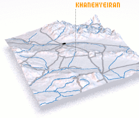 Places with similar names to Khāneh-ye Īrān, Iran :: Disclaimer :: Information on this page comes without warranty of any kind |
||
|
Where is Khāneh-ye Īrān? Elevation and coordinates ::
Latitude (lat): 36°38'0"N Longitude (lon): 48°35'0"E
Elevation (approx.): 1668m (map arrows pan, magnifying glasses zoom) |
||
|
Visiting Khāneh-ye Īrān? Hotel/Accommodation ::
Book a hotel in Khāneh-ye Īrān Travel Guide ::
Buy a travel guide for Iran rental cars ::
car rental offers GPS waypoint ::
download a GPX waypoint (PoI) of Khāneh-ye Īrān for your GPS receiver
|
||