|
search place name
|
||
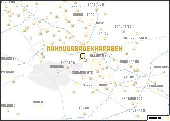
Maḩmūdābād-e Kharābeh (Khorāsān, Iran)Maḩmūdābād-e Kharābeh is a town in the Khorāsān region of Iran. An overview map of the region around Maḩmūdābād-e Kharābeh is displayed below.
regional and 3d topo map of Maḩmūdābād-e Kharābeh, Iran ::
Maḩmūdābād-e Kharābeh airports ::
The nearest airport is ASB - Ashkhabad Ashgabat, located 218.5 km north west of Maḩmūdābād-e Kharābeh.
Nearby towns ::
Raddeh (0.0km east) //
Dīsh Dīsh (0.9km west) //
Qal‘eh-ye Gol Shūr (1.3km south east) //
Khaţīb (1.5km east) //
Nīkrūz (1.6km east) //
Kalāteh-ye Mollā ‘Alī (2.3km north west) //
Jow Forūsh (2.3km north west) //
Sīsābād (2.4km north) //
Deh Moz̧affar (2.3km north east) //
‘Eyshābād (2.5km south east) //
Charkh-e Falak (2.4km north east) //
Ḩoseynābād (2.6km north west) //
Neyzeh (2.4km south east) //
Deh Rūd (3.3km north) //
Now Kārīz (2.8km east) //
Ḩoseynābād (3.2km south east) //
Allāh Teymūr (3.0km east) //
Kheder Beyk (3.8km south) //
Hemmatābād (3.8km north) //
Gorjī-ye Pā'īn (3.9km north) //
Ebrāhīmābād (4.0km south) //
Gevandūk (4.0km north east) //
Zeyn od Dīn (3.5km north east) //
Hoseynābād-e Kermānīhā (3.5km south west) //
Mehrābād (3.5km south west) //
Ḩalvā'ī (3.6km south east) //
Pāvā (3.6km south east) //
Rūhābād (4.3km south east) //
Shīr Ḩeşār (4.0km north east) //
[all distances 'as the bird flies' and approximate] 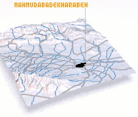 Places with similar names to Maḩmūdābād-e Kharābeh, Iran :: Disclaimer :: Information on this page comes without warranty of any kind |
||
|
Where is Maḩmūdābād-e Kharābeh? Elevation and coordinates ::
Latitude (lat): 36°19'3"N Longitude (lon): 59°39'57"E
Elevation (approx.): 948m (map arrows pan, magnifying glasses zoom) |
||
|
Visiting Maḩmūdābād-e Kharābeh? Hotel/Accommodation ::
Book a hotel in Maḩmūdābād-e Kharābeh Travel Guide ::
Buy a travel guide for Iran rental cars ::
car rental offers GPS waypoint ::
download a GPX waypoint (PoI) of Maḩmūdābād-e Kharābeh for your GPS receiver
|
||