|
search place name
|
||
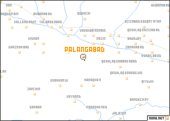
Palangābād (Iran)Palangābād is a town in Iran. An overview map of the region around Palangābād is displayed below.
regional and 3d topo map of Palangābād, Iran ::
Palangābād airports ::
The nearest airport is THR - Teheran Mehrabad Intl, located 144.3 km north east of Palangābād.
Other airports nearby include RZR - Ramsar (221.5 km north), Nearby towns ::
Qīājīk (4.0km north) //
Qayeh Jīk (4.0km north) //
Āshīānak (3.6km north west) //
Rāzīn (4.8km north east) //
Şafīābād (5.6km north) //
Maraq (5.6km south) //
Varak Bār-e Pā'īn (5.8km north) //
Maraqkān (5.8km south) //
Arjrūd (6.3km north west) //
Jamshīdābād (7.3km north) //
Jalāyer (6.3km east) //
Emām Kandī (7.2km south west) //
Emāmzādeh Khūraq (7.2km north east) //
Qeyţānīyeh (7.2km north east) //
Qeshlāq-e ‘Abbāsābād (6.5km east) //
Band-e Naqī (7.1km north east) //
Sūsan Naqīn (8.2km north east) //
Sūlāb (8.7km north west) //
Yūldāshābād (9.6km north west) //
Chehel Gazī (9.6km north west) //
[all distances 'as the bird flies' and approximate]  Places with similar names to Palangābād, Iran ::
Disclaimer :: Information on this page comes without warranty of any kind |
||
|
Where is Palangābād? Elevation and coordinates ::
Latitude (lat): 35°0'0"N Longitude (lon): 49°58'0"E
Elevation (approx.): 1756m (map arrows pan, magnifying glasses zoom) |
||
|
Visiting Palangābād? Hotel/Accommodation ::
Book a hotel in Palangābād Travel Guide ::
Buy a travel guide for Iran rental cars ::
car rental offers GPS waypoint ::
download a GPX waypoint (PoI) of Palangābād for your GPS receiver
|
||