|
search place name
|
||
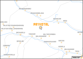
Pāy Kotal (Khorāsān, Iran)Pāy Kotal is a town in the Khorāsān region of Iran. An overview map of the region around Pāy Kotal is displayed below.
regional and 3d topo map of Pāy Kotal, Iran ::
Pāy Kotal airports ::
The nearest airport is ASB - Ashkhabad Ashgabat, located 80.8 km north of Pāy Kotal.
Nearby towns ::
Qal‘eh Sharaf (4.0km south) //
Solţān Zīrābeh (4.2km south east) //
Yādegār (4.5km south west) //
Īncheh Keykānlū (6.2km north) //
Īncheh Sābolāgh (6.7km north) //
Emām Verdīkhān (7.1km south east) //
Āghmazār (6.9km north east) //
Kalāteh-ye Rasūl (6.8km north east) //
Īncheh Shāhbāz (10.4km north west) //
[all distances 'as the bird flies' and approximate]  Places with similar names to Pāy Kotal, Iran ::
// Pocatello (US)
// Peckatel (DE)
// Peckatel (DE)
// Poggetello (IT)
// Pigadoúlia (GR)
// Pākdāl (BD)
// Pukdale (ID)
// Puctla (MX)
// Pekh Tal (SN)
// Pakka Dalla (PK)
Disclaimer :: Information on this page comes without warranty of any kind |
||
|
Where is Pāy Kotal? Elevation and coordinates ::
Latitude (lat): 37°17'19"N Longitude (lon): 58°37'12"E
Elevation (approx.): 1721m (map arrows pan, magnifying glasses zoom) |
||
|
Visiting Pāy Kotal? Hotel/Accommodation ::
Book a hotel in Pāy Kotal Travel Guide ::
Buy a travel guide for Iran rental cars ::
car rental offers GPS waypoint ::
download a GPX waypoint (PoI) of Pāy Kotal for your GPS receiver
|
||