|
search place name
|
||
Pīr Sohrāb (Sīstān va Balūchestān, Iran)Pīr Sohrāb is a town in the Sīstān va Balūchestān region of Iran. An overview map of the region around Pīr Sohrāb is displayed below.
regional and 3d topo map of Pīr Sohrāb, Iran ::

Pīr Sohrāb airports ::
The nearest airport is ZBR - Chah Bahar, located 59.3 km south west of Pīr Sohrāb.
Other airports nearby include GWD - Gwadar (156.3 km east), Nearby towns ::
Bandgāh-e Pīr Sohrāb (1.7km south) //
Fatḩ ‘Alī Kalāt (2.6km south east) //
Koch (3.0km south) //
Būneʼū (3.3km south) //
Qamdād-e Bāzār (3.1km north west) //
Kallah Sakān (3.5km north west) //
Regetī-ye Pā`īn (3.8km north) //
Mīr Benze'ī (5.4km south east) //
Chahār Nūk (5.8km south) //
Bībān Zehī (5.6km south east) //
Pīr Nowkūh (5.6km south east) //
‘Owrakī (5.9km east) //
Koch (7.0km west) //
Nāmbīt (7.9km west) //
Şafar Zehī (8.5km south east) //
Zahrāb (8.9km south) //
Pettī (9.7km south east) //
Bon Now (10.3km south east) //
‘Os̄mān Bāzār (10.6km south east) //
[all distances 'as the bird flies' and approximate] 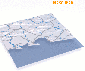 Places with similar names to Pīr Sohrāb, Iran ::
Disclaimer :: Information on this page comes without warranty of any kind |
||
|
Where is Pīr Sohrāb? Elevation and coordinates ::
Latitude (lat): 25°44'7"N Longitude (lon): 60°52'36"E
Elevation (approx.): 54m (map arrows pan, magnifying glasses zoom) |
||
|
Visiting Pīr Sohrāb? Hotel/Accommodation ::
Book a hotel in Pīr Sohrāb Travel Guide ::
Buy a travel guide for Iran rental cars ::
car rental offers GPS waypoint ::
download a GPX waypoint (PoI) of Pīr Sohrāb for your GPS receiver
|
||