|
search place name
|
||
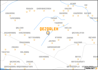
Qez Qal‘eh (Iran)Qez Qal‘eh is a town in Iran. An overview map of the region around Qez Qal‘eh is displayed below.
regional and 3d topo map of Qez Qal‘eh, Iran ::
Qez Qal‘eh airports ::
The nearest airport is RZR - Ramsar, located 86.8 km north of Qez Qal‘eh.
Other airports nearby include THR - Teheran Mehrabad Intl (93.2 km south east), RAS - Rasht (150.7 km north west), Nearby towns ::
Jazmeh (3.3km south) //
Ātānak (3.5km south east) //
Tūdārān (4.8km north east) //
Dār os Sarvar (5.8km south) //
Ţīkhūr (5.8km north) //
Seyyedābād (4.9km west) //
Kahvān (5.8km north east) //
Kaz̄lak (6.3km east) //
Zīārān (6.8km east) //
Ahvārak (8.7km north east) //
Shekar Nāb (11.2km north west) //
[all distances 'as the bird flies' and approximate] 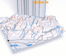 Places with similar names to Qez Qal‘eh, Iran ::
// Keçikli (AZ)
// Qazqulu (AZ)
// Gaskil (US)
// Casa Cola (US)
// Kaschel (DE)
// Kühzagl (DE)
// Casa Cola (IT)
// Casaglia (IT)
// Case Galli (IT)
// Koziegłowy (PL)
Disclaimer :: Information on this page comes without warranty of any kind |
||
|
Where is Qez Qal‘eh? Elevation and coordinates ::
Latitude (lat): 36°9'0"N Longitude (lon): 50°27'0"E
Elevation (approx.): 1571m (map arrows pan, magnifying glasses zoom) |
||
|
Visiting Qez Qal‘eh? Hotel/Accommodation ::
Book a hotel in Qez Qal‘eh Travel Guide ::
Buy a travel guide for Iran rental cars ::
car rental offers GPS waypoint ::
download a GPX waypoint (PoI) of Qez Qal‘eh for your GPS receiver
|
||