|
search place name
|
||
Sālārābād (Ostān-e Āz̄arbāyjān-e Gharbī, Iran)Sālārābād is a town in the Ostān-e Āz̄arbāyjān-e Gharbī region of Iran. An overview map of the region around Sālārābād is displayed below.
regional and 3d topo map of Sālārābād, Iran ::

Sālārābād airports ::
The nearest airport is TBZ - Tabriz Intl, located 108.1 km north of Sālārābād.
Other airports nearby include SDG - Sanandaj (234.5 km south east), Nearby towns ::
Majīdābād (0.0km north) //
Aḩmadābād (1.5km east) //
Jamshīdābād (1.7km north west) //
Manşūrābād (4.0km south) //
Qepchāq (5.2km south east) //
Yūlqūnlū-ye Qadīm (4.4km east) //
Ebrāhīm Ḩeşārī (5.8km south) //
Qareh Qeshlāq (5.9km north) //
Ḩājjī Moşayyeb (6.3km north east) //
Āghdāsh (5.8km south west) //
Sha‘bānlū (8.0km south) //
Sharānlū (7.0km south east) //
Chahār Borj-e Qadīm (8.4km south) //
Chopoqlū (7.3km east) //
Khazīneh Anbār-e Qadīm (8.6km south east) //
Khazīneh Anbār-e Jadīd (9.5km south east) //
[all distances 'as the bird flies' and approximate] 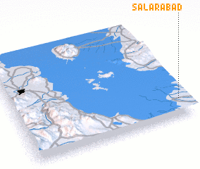 Places with similar names to Sālārābād, Iran ::
Disclaimer :: Information on this page comes without warranty of any kind |
||
|
Where is Sālārābād? Elevation and coordinates ::
Latitude (lat): 37°11'0"N Longitude (lon): 45°58'0"E
Elevation (approx.): 1280m (map arrows pan, magnifying glasses zoom) |
||
|
Visiting Sālārābād? Hotel/Accommodation ::
Book a hotel in Sālārābād Travel Guide ::
Buy a travel guide for Iran rental cars ::
car rental offers GPS waypoint ::
download a GPX waypoint (PoI) of Sālārābād for your GPS receiver
|
||