|
search place name
|
||
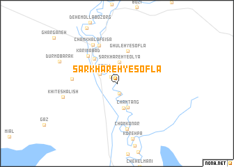
Sar Khareh-ye Soflá (Khūzestān, Iran)Sar Khareh-ye Soflá is a town in the Khūzestān region of Iran. An overview map of the region around Sar Khareh-ye Soflá is displayed below.
regional and 3d topo map of Sar Khareh-ye Soflá, Iran ::
Sar Khareh-ye Soflá airports ::
The nearest airport is MRX - Bandar Mahshahr Mahshahr, located 56.6 km west of Sar Khareh-ye Soflá.
Other airports nearby include AWZ - Ahwaz (137.2 km north west), ABD - Abadan (143.3 km west), QMJ - Masjed Soleiman Shahid Asyaee (181.1 km north), BUZ - Bushehr (195.5 km south east), Nearby towns ::
Jīrī-ye Soflá (1.3km north west) //
Nāşerābād (1.6km south) //
Elī (2.0km north) //
Feylī (2.7km north west) //
Fīrūzābād (2.8km north west) //
Sarkhareh-ye ‘Olyā (3.5km north) //
Cham Kalgeh (4.1km south) //
Cham Tang (4.1km south) //
Jīrī-ye ‘Olyā (4.0km north west) //
Cham Kharnūb (5.1km north west) //
Ghūleh-ye Soflá (5.4km north) //
Karīmābād (5.9km north west) //
Darīhak (6.6km north) //
Dūreh Marzūq (6.3km west) //
Cham Khalaf-e ‘Īsá (7.1km north west) //
Cham Konār (7.4km south) //
Khīţ-e Shalīsh (7.8km west) //
Deh-e Mollā Kūchek (9.8km north west) //
[all distances 'as the bird flies' and approximate] 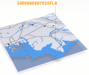 Places with similar names to Sar Khareh-ye Soflá, Iran :: Disclaimer :: Information on this page comes without warranty of any kind |
||
|
Where is Sar Khareh-ye Soflá? Elevation and coordinates ::
Latitude (lat): 30°24'55"N Longitude (lon): 49°43'8"E
Elevation (approx.): 14m (map arrows pan, magnifying glasses zoom) |
||
|
Visiting Sar Khareh-ye Soflá? Hotel/Accommodation ::
Book a hotel in Sar Khareh-ye Soflá Travel Guide ::
Buy a travel guide for Iran rental cars ::
car rental offers GPS waypoint ::
download a GPX waypoint (PoI) of Sar Khareh-ye Soflá for your GPS receiver
|
||