|
search place name
|
||
Serāj Maḩalleh (Iran)Serāj Maḩalleh is a town in Iran. An overview map of the region around Serāj Maḩalleh is displayed below.
regional and 3d topo map of Serāj Maḩalleh, Iran ::

Nearby towns ::
Tīleh Now (0.5km east) //
Khūzshīd Kolā (0.5km east) //
Noşratābād (1.2km south) //
Tīr Tāsh (1.9km west) //
Khvorshīd Kolā (2.8km north east) //
Nez̧ām Maḩalleh (2.7km east) //
Tappeh (3.5km east) //
Emāmzādeh Aḩmad (3.9km west) //
Zelang Key (4.4km north west) //
Galūgāh (4.5km east) //
Yakh Kesh (6.1km south) //
Valamāzū (5.0km west) //
‘Abdollāhī (5.8km north east) //
Hasht Tīkeh (5.3km east) //
Lemrāsk (5.4km west) //
Cheshmeh Bolbol (6.7km east) //
Valeh Mūzū (7.2km west) //
Valeh Mūzū (7.9km north west) //
[all distances 'as the bird flies' and approximate] 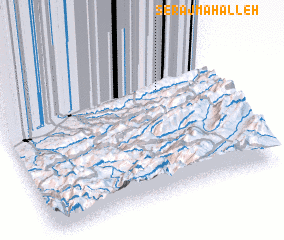 Places with similar names to Serāj Maḩalleh, Iran ::
// Sarāj Maḩalleh (IR)
// Serāj Maḩalleh (IR)
Disclaimer :: Information on this page comes without warranty of any kind |
||
|
Where is Serāj Maḩalleh? Elevation and coordinates ::
Latitude (lat): 36°42'58"N Longitude (lon): 53°45'39"E
Elevation (approx.): 44m (map arrows pan, magnifying glasses zoom) |
||
|
Visiting Serāj Maḩalleh? Hotel/Accommodation ::
Book a hotel in Serāj Maḩalleh Travel Guide ::
Buy a travel guide for Iran rental cars ::
car rental offers GPS waypoint ::
download a GPX waypoint (PoI) of Serāj Maḩalleh for your GPS receiver
|
||