|
search place name
|
||
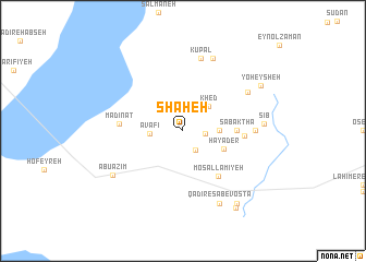
Shaḩeh (Khūzestān, Iran)Shaḩeh is a town in the Khūzestān region of Iran. An overview map of the region around Shaḩeh is displayed below.
regional and 3d topo map of Shaḩeh, Iran ::
Shaḩeh airports ::
The nearest airport is MRX - Bandar Mahshahr Mahshahr, located 47.4 km south of Shaḩeh.
Other airports nearby include AWZ - Ahwaz (52.9 km north west), ABD - Abadan (110.1 km south west), QMJ - Masjed Soleiman Shahid Asyaee (113.7 km north), BSR - Basrah Intl (148.8 km west), Nearby towns ::
Abū Yūrev (1.9km east) //
Abū Yūrū (2.2km south east) //
Avāfī (2.9km west) //
Khed (3.3km north east) //
Boneh Sūkhteh-ye ‘Olyā (3.2km east) //
Ḩayāder (4.1km south east) //
Sabaktha (4.8km east) //
Mosallamīyeh (5.5km south east) //
Boneh Sūkhteh (5.5km east) //
Madīnāt (5.7km west) //
Baithe Mandīl (6.4km east) //
Kūpāl (7.6km north) //
Ḩomeyreh (6.9km north east) //
Kereydī (7.9km north) //
Qadīr-e Sab‘-e Vosţá (8.1km south east) //
Sīb (7.2km east) //
Abū ‘Az̧īm (7.7km south west) //
Yoheysheh (8.3km north east) //
Qadīr-e Sab‘-e ‘Olyā (8.8km south east) //
Qadīr-e Sab‘ (9.2km south east) //
[all distances 'as the bird flies' and approximate] 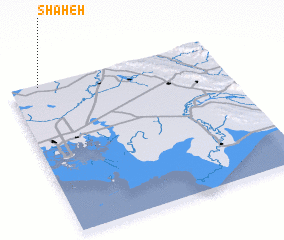 Places with similar names to Shaḩeh, Iran ::
Disclaimer :: Information on this page comes without warranty of any kind |
||
|
Where is Shaḩeh? Elevation and coordinates ::
Latitude (lat): 30°59'0"N Longitude (lon): 49°8'0"E
Elevation (approx.): 22m (map arrows pan, magnifying glasses zoom) |
||
|
Visiting Shaḩeh? Hotel/Accommodation ::
Book a hotel in Shaḩeh Travel Guide ::
Buy a travel guide for Iran rental cars ::
car rental offers GPS waypoint ::
download a GPX waypoint (PoI) of Shaḩeh for your GPS receiver
|
||