|
search place name
|
||
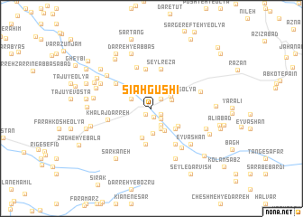
Sīāh Gūshī (Lorestān, Iran)Sīāh Gūshī is a town in the Lorestān region of Iran. An overview map of the region around Sīāh Gūshī is displayed below.
regional and 3d topo map of Sīāh Gūshī, Iran ::
Sīāh Gūshī airports ::
The nearest airport is QMJ - Masjed Soleiman Shahid Asyaee, located 174.9 km south of Sīāh Gūshī.
Other airports nearby include KSH - Bakhtaran Shahid Ashrafi Esfahani (175.0 km north west), SDG - Sanandaj (250.7 km north west), Nearby towns ::
Ḩeyvānī (0.9km south west) //
Eyvānī (1.0km south) //
Nowmāleh-ye ‘Olyā (1.2km south east) //
Haft Cheshmeh (1.2km south east) //
Rangrazān-e Soflá (1.5km north east) //
Rangrazān-e Vasaţī (1.5km north east) //
Nowmāleh-ye Soflá (1.6km south east) //
Chaghalvand Rūd-e Soflá (2.3km south east) //
Koleh Jūb-e Bālā (2.4km north east) //
Dehnow (2.7km south) //
Rangrazān-e ‘Olyā (2.5km north east) //
Tūmāleh-ye Soflá (2.4km north west) //
Nūrābād-e Cheshmeh Kūzeh (3.1km south) //
Zarrīnābād (3.0km south east) //
‘Alīābād (3.8km south) //
Chaghalvand Rūd-e ‘Olyā (3.6km south east) //
Chaqalvand-e Pāʼīn (3.6km south east) //
Gol Darreh (3.5km south east) //
Khalaj Darreh (3.6km north west) //
Pāy Tappeh-ye ‘Eyvonī (4.4km south) //
Malekābād-e Kamālvand (4.4km south) //
Seyl Karīm (4.9km north) //
Seyl Reẕā (5.0km north) //
Keykamdar (5.0km south east) //
Eslāmābād (5.0km south east) //
Khalīlān-e Soflá (4.8km north west) //
Khersdar (5.3km north) //
Khalaj Darreh (4.7km west) //
Qal‘eh-ye Hādī Chakmeh Sīāh (5.8km south east) //
[all distances 'as the bird flies' and approximate]  Places with similar names to Sīāh Gūshī, Iran ::
Disclaimer :: Information on this page comes without warranty of any kind |
||
|
Where is Sīāh Gūshī? Elevation and coordinates ::
Latitude (lat): 33°31'22"N Longitude (lon): 48°46'23"E
Elevation (approx.): 1751m (map arrows pan, magnifying glasses zoom) |
||
|
Visiting Sīāh Gūshī? Hotel/Accommodation ::
Book a hotel in Sīāh Gūshī Travel Guide ::
Buy a travel guide for Iran rental cars ::
car rental offers GPS waypoint ::
download a GPX waypoint (PoI) of Sīāh Gūshī for your GPS receiver
|
||