|
search place name
|
||
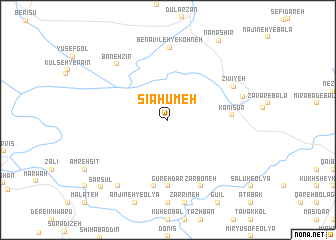
Sīāḩūmeh (Kordestān, Iran)Sīāḩūmeh is a town in the Kordestān region of Iran. An overview map of the region around Sīāḩūmeh is displayed below.
regional and 3d topo map of Sīāḩūmeh, Iran ::
Sīāḩūmeh airports ::
The nearest airport is SDG - Sanandaj, located 149.6 km south east of Sīāḩūmeh.
Other airports nearby include KSH - Bakhtaran Shahid Ashrafi Esfahani (231.9 km south east), Nearby towns ::
Kānīsūr (5.8km east) //
Gūrehdār (7.4km south) //
Bolḩasan (7.5km south) //
Bolḩasan (7.5km south) //
Benāvīleh-ye Kohneh (8.1km north) //
Zīvīyeh (7.0km north east) //
Vāzheh (8.0km south) //
Zarboneh (8.0km south) //
Bānehzīr (7.8km north west) //
Seyyed Şārem (7.2km east) //
Anjīneh-ye Soflá (8.7km south west) //
Namashīr (10.0km north east) //
Sarsūl (9.7km south west) //
[all distances 'as the bird flies' and approximate]  Places with similar names to Sīāḩūmeh, Iran ::
// Chae Hom (TH)
// Chāh Ambāh (IR)
// Shahāma (IN)
// Chihombo (ZM)
// ((Shāhimah)) (IQ)
// Chāh-e Ma‘ī (IR)
// Chāh-e Ma‘ī (IR)
// Chehama (DZ)
// Chihama (JP)
// Shiohama (JP)
Disclaimer :: Information on this page comes without warranty of any kind |
||
|
Where is Sīāḩūmeh? Elevation and coordinates ::
Latitude (lat): 36°3'0"N Longitude (lon): 45°41'0"E
Elevation (approx.): 1448m (map arrows pan, magnifying glasses zoom) |
||
|
Visiting Sīāḩūmeh? Hotel/Accommodation ::
Book a hotel in Sīāḩūmeh Travel Guide ::
Buy a travel guide for Iran rental cars ::
car rental offers GPS waypoint ::
download a GPX waypoint (PoI) of Sīāḩūmeh for your GPS receiver
|
||