|
search place name
|
||
Sīsakht (Ostān-e Kohgīlūyeh va Būyer Aḩmad, Iran)Sīsakht is a town in the Ostān-e Kohgīlūyeh va Būyer Aḩmad region of Iran. An overview map of the region around Sīsakht is displayed below.
regional and 3d topo map of Sīsakht, Iran ::

Sīsakht airports ::
The nearest airport is SYZ - Shiraz Shahid Dastghaib Intl, located 183.1 km south east of Sīsakht.
Other airports nearby include BUZ - Bushehr (221.3 km south), Nearby towns ::
Ḩoseynābād (2.0km south east) //
Qal‘eh-ye Markazī (2.7km south west) //
Eqbālābād (3.3km south) //
Darreh Chāt (3.6km south west) //
‘Alīābād (3.7km south) //
‘Abbāsābād (4.1km south) //
Kokhedān (4.4km south) //
Sar Mūr (4.4km south east) //
Deh Now (4.3km south east) //
Bīāreh (4.8km south east) //
Kohleh-ye Pīshvar (5.5km south) //
Eshkaft-e Havā'ī (5.2km west) //
Kelkel-e ‘Abbāsābād (6.0km south) //
Amīrābād (6.5km south) //
Tang-e Garmū (5.7km east) //
Eshkaft-e Havā'ī (5.8km west) //
Kohleh-ye Pīshvar (7.3km south) //
Nūreh (7.3km south) //
Tang-e Shotor Rīz (7.2km east) //
Ḩasanābād (8.7km south west) //
Karīak (8.5km south west) //
‘Abbāsābād (9.4km south west) //
Tang-e Gerdū'ī (9.3km north east) //
Āb Garmak-e Pā'īn (10.8km south west) //
[all distances 'as the bird flies' and approximate] 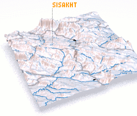 Places with similar names to Sīsakht, Iran ::
Disclaimer :: Information on this page comes without warranty of any kind |
||
|
Where is Sīsakht? Elevation and coordinates ::
Latitude (lat): 30°51'57"N Longitude (lon): 51°27'24"E
Elevation (approx.): 2322m (map arrows pan, magnifying glasses zoom) |
||
|
Visiting Sīsakht? Hotel/Accommodation ::
Book a hotel in Sīsakht Travel Guide ::
Buy a travel guide for Iran rental cars ::
car rental offers GPS waypoint ::
download a GPX waypoint (PoI) of Sīsakht for your GPS receiver
|
||