|
search place name
|
||
Somāqcheh (Khorāsān, Iran)Somāqcheh is a town in the Khorāsān region of Iran. An overview map of the region around Somāqcheh is displayed below.
regional and 3d topo map of Somāqcheh, Iran ::
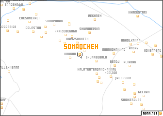
Nearby towns ::
Chenār Bowy (1.7km north) //
Khūk Āb (2.2km west) //
Kārīz Veleng (3.2km north) //
Shūrāb-e Bālā (2.9km east) //
Kārīz Sūkhteh (3.6km north) //
Bāghak (3.2km north west) //
Kalāteh-ye Āqā Moḩammad (4.6km south east) //
Chahār Bīd (4.6km north west) //
Sūd Khvor (5.3km north) //
Shūrāb-e Pā'īn (6.0km north) //
Sībak-e Pā'īn (5.6km south east) //
Kārīz Gerdeleh (5.6km north west) //
Kārīz-e Bedāgh (6.0km north west) //
Sībak-e Bālā (6.3km south east) //
Khāk Shūr (6.8km south east) //
Amān Moḩammad (6.2km east) //
Berdū (6.4km east) //
Kārīzān (7.0km south east) //
Ḩasan Bolbol (8.0km north) //
Khalīlābād (8.3km north) //
Rekhneh (9.2km north) //
Shokrābād (9.2km north west) //
Golestān (8.8km north west) //
Ţarāz-e Khākī (9.8km north west) //
[all distances 'as the bird flies' and approximate]  Places with similar names to Somāqcheh, Iran ::
// Šimkaičiai (LT)
// Smukučiai (LT)
// Semococh (GT)
// Semococh (GT)
// Samukiche (ZM)
// Samicucho (PE)
// Xóm Cả Chợ (VN)
// Xóm Cây Chỏ (VN)
// Sembokuchō (JP)
// Semukachi (BY)
Disclaimer :: Information on this page comes without warranty of any kind |
||
|
Where is Somāqcheh? Elevation and coordinates ::
Latitude (lat): 35°27'51"N Longitude (lon): 60°3'24"E
Elevation (approx.): 1514m (map arrows pan, magnifying glasses zoom) |
||
|
Visiting Somāqcheh? Hotel/Accommodation ::
Book a hotel in Somāqcheh Travel Guide ::
Buy a travel guide for Iran rental cars ::
car rental offers GPS waypoint ::
download a GPX waypoint (PoI) of Somāqcheh for your GPS receiver
|
||