|
search place name
|
||
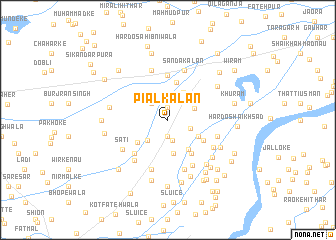
Piāl Kalān (Punjab, Pakistan)Piāl Kalān is a town in the Punjab region of Pakistan. An overview map of the region around Piāl Kalān is displayed below.
regional and 3d topo map of Piāl Kalān, Pakistan ::
Piāl Kalān airports ::
The nearest airport is LHE - Lahore Allama Iqbal Intl, located 69.0 km north of Piāl Kalān.
Other airports nearby include ATQ - Amritsar (103.0 km north east), LYP - Faisalabad Intl (128.1 km north west), LUH - Ludhiaha Ludhiana (164.5 km east), IXP - Pathankot (197.5 km north east), Nearby towns ::
Weir (1.4km north) //
Usmānwāla (1.9km south) //
Warsleganj (2.4km south) //
Dhing Shāh (2.4km north west) //
Piāl Khurd (2.3km south east) //
Nainwāl Jāgīr (2.8km north east) //
Basti Arāiān (3.1km south west) //
Kachcha Pakka Khurd (3.4km north east) //
Bāgh Singhwāla (3.7km south) //
Mahlam (3.5km south east) //
Kot Khatriān (3.8km south east) //
Dāoke Kalān (3.8km south west) //
Nandanpura (4.2km north) //
Gauhar (4.3km south east) //
Nūrpur Dogrān (4.2km south east) //
Kachcha Pakka Kalān (4.9km north) //
Dāoke Khaniāna (4.9km south west) //
Killi (5.6km south east) //
Khaniāna Ābādi Chaudhriān (5.5km south west) //
Khāi Hithār (5.8km north) //
Begpur (5.8km north) //
Qila Dāoke (5.8km south) //
Jodhwāla (5.1km east) //
Killi Sokāl (5.8km south) //
Sanda Kalān (5.8km north) //
Theh Kāmjl (5.4km south east) //
Sati (5.4km south west) //
Shekhūpura (5.9km south east) //
Langewāla (6.2km south east) //
[all distances 'as the bird flies' and approximate]  Places with similar names to Piāl Kalān, Pakistan ::
// Plakálona (GR)
// Piliakalniai (LT)
// Piliakalniai (LT)
// Pelgulinn (EE)
// Palo Galán (SV)
// Palo Galán (SV)
// Paliā Kalān (IN)
// Polaia Kalān (IN)
// Pīlah Galīn (IR)
Disclaimer :: Information on this page comes without warranty of any kind |
||
|
Where is Piāl Kalān? Elevation and coordinates ::
Latitude (lat): 30°55'0"N Longitude (lon): 74°14'0"E
Elevation (approx.): 190m (map arrows pan, magnifying glasses zoom) |
||
|
Visiting Piāl Kalān? Hotel/Accommodation ::
Book a hotel in Piāl Kalān Travel Guide ::
Buy a travel guide for Pakistan rental cars ::
car rental offers GPS waypoint ::
download a GPX waypoint (PoI) of Piāl Kalān for your GPS receiver
|
||