|
search place name
|
||
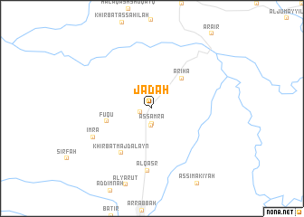
Jad‘ah (Al Karak, Jordan)Jad‘ah is a town in the Al Karak region of Jordan. An overview map of the region around Jad‘ah is displayed below.
regional and 3d topo map of Jad‘ah, Jordan ::
Jad‘ah airports ::
The nearest airport is AMM - Amman Queen Alia Intl, located 44.1 km north east of Jad‘ah.
Other airports nearby include ADJ - Amman Marka Intl (69.2 km north), BEV - Beer-sheba Teyman (98.3 km west), TLV - Tel-aviv Ben Gurion (107.5 km north west), OMF - Mafraq King Hussein (118.2 km north east), Nearby towns ::
Khirbat Shīḩān (1.3km west) //
As Samrāʼ (1.9km south) //
Jad‘at al Jubūr (2.1km south) //
Mughayyir (2.4km north east) //
Abū Turābah (4.9km north east) //
Arīḩā (4.9km north east) //
Fuqū‘ (5.1km west) //
Khirbat Majdalayn (6.4km south west) //
Al Qaşr (7.7km south) //
Imra‘ (7.1km south west) //
[all distances 'as the bird flies' and approximate]  Places with similar names to Jad‘ah, Jordan ::
Disclaimer :: Information on this page comes without warranty of any kind |
||
|
Where is Jad‘ah? Elevation and coordinates ::
Latitude (lat): 31°23'0"N Longitude (lon): 35°45'0"E
Elevation (approx.): 957m (map arrows pan, magnifying glasses zoom) |
||
|
Visiting Jad‘ah? Hotel/Accommodation ::
Book a hotel in Jad‘ah Travel Guide ::
Buy a travel guide for Jordan rental cars ::
car rental offers GPS waypoint ::
download a GPX waypoint (PoI) of Jad‘ah for your GPS receiver
|
||