|
search place name
|
||
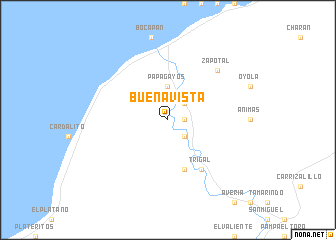
Buena Vista (Tumbes, Peru)Buena Vista is a town in the Tumbes region of Peru. An overview map of the region around Buena Vista is displayed below.
regional and 3d topo map of Buena Vista, Peru ::
Buena Vista airports ::
The nearest airport is TBP - Tumbes Pedro Canga, located 45.2 km north east of Buena Vista.
Other airports nearby include MCH - Machala General Manuel Serrano (101.4 km north east), TYL - Talara Capitan Montes (106.1 km south west), PIU - Piura Capitan Fap Guillermo Concha Iberico (157.7 km south), SNC - Salinas General Ulpiano Paez (177.1 km north), Nearby towns ::
Pedregal (1.8km east) //
Faical (2.6km north east) //
Peña Redonda (2.6km south east) //
Suárez (2.6km south east) //
Huacura (3.7km north) //
Papagayos (3.7km north) //
Pan Viejo (5.9km south) //
Trigal (6.7km south east) //
Serrano (6.7km south east) //
Zapotal (7.9km north east) //
[all distances 'as the bird flies' and approximate] 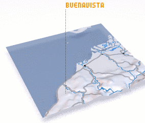 Places with similar names to Buena Vista, Peru ::
// Buenavista (PH)
// Buenavista (PH)
// Buenavista (PH)
// Buenavista (PH)
// Buenavista (PH)
// Buena Vista (PH)
// Buena Vista (PH)
// Buena Vista (PH)
// Buenavista (PH)
// Buenavista (PH)
Disclaimer :: Information on this page comes without warranty of any kind |
||
|
Where is Buena Vista? Elevation and coordinates ::
Latitude (lat): 3°47'0"S Longitude (lon): 80°43'0"W
Elevation (approx.): 29m (map arrows pan, magnifying glasses zoom) |
||
|
Visiting Buena Vista? Hotel/Accommodation ::
Book a hotel in Buena Vista Travel Guide ::
Buy a travel guide for Peru rental cars ::
car rental offers GPS waypoint ::
download a GPX waypoint (PoI) of Buena Vista for your GPS receiver
|
||