|
search place name
|
||
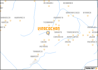
Viracochán (Apurímac, Peru)Viracochán is a town in the Apurímac region of Peru. An overview map of the region around Viracochán is displayed below.
regional and 3d topo map of Viracochán, Peru ::
Viracochán airports ::
The nearest airport is ANS - Andahuaylas, located 58.6 km west of Viracochán.
Other airports nearby include CUZ - Cuzco Teniente Alejandro Velasco Astete Intl (96.8 km east), AYP - Ayacucho Coronel Fap Alfredo Mendivil Duarte (154.8 km west), Nearby towns ::
Puquio (1.9km south) //
Asil (2.6km north east) //
Arapoto (2.6km south west) //
Ticabamba (3.7km north) //
Saihute (3.6km east) //
Cocha (4.1km south west) //
Concacha (4.1km south east) //
Marcopata (4.1km north east) //
Cotabamba (4.1km north west) //
Cachora (4.8km north east) //
Pacobamba (5.2km north east) //
Pucyutan (5.2km north east) //
Apayhuana (5.8km north) //
Potrero (5.8km south) //
Rosapata (6.6km north east) //
Mazocaca (7.4km east) //
Vacas (8.1km south east) //
Tamburco (8.5km south west) //
Poyonco (10.3km north east) //
[all distances 'as the bird flies' and approximate] 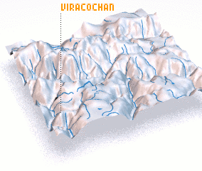 Places with similar names to Viracochán, Peru ::
// Vorogushino (RU)
Disclaimer :: Information on this page comes without warranty of any kind |
||
|
Where is Viracochán? Elevation and coordinates ::
Latitude (lat): 13°33'0"S Longitude (lon): 72°50'0"W
Elevation (approx.): 4002m (map arrows pan, magnifying glasses zoom) |
||
|
Visiting Viracochán? Hotel/Accommodation ::
Book a hotel in Viracochán Travel Guide ::
Buy a travel guide for Peru rental cars ::
car rental offers GPS waypoint ::
download a GPX waypoint (PoI) of Viracochán for your GPS receiver
|
||