|
search place name
|
||
El Laguatal (Zulia, Venezuela)El Laguatal is a town in the Zulia region of Venezuela. An overview map of the region around El Laguatal is displayed below.
regional and 3d topo map of El Laguatal, Venezuela ::

El Laguatal airports ::
The nearest airport is MAR - Maracaibo La Chinita Intl, located 41.6 km north west of El Laguatal.
Other airports nearby include VLV - Valera Dr Antonio Nicolas Briceno (146.3 km south east), STB - Santa Barbara Del Zulia (169.2 km south), MRD - Merida Alberto Carnevalli (202.5 km south), LSP - Paraguana Josefa Camejo (203.6 km north east), Nearby towns ::
El Matrimonio (0.0km north) //
Proa del Norte (0.0km north) //
El Cobito (0.0km north) //
Patiecito (1.9km south) //
Cobito Viejo (1.9km south) //
Cañada Honda (2.6km south east) //
Tumba (2.6km south west) //
El Jabón (2.6km north west) //
La Vuelta (3.0km north east) //
Las Veritas (3.7km south) //
El Diamante (3.7km north east) //
Pedregalito (4.0km south west) //
San Antonio (4.1km south west) //
La Candelaria (4.2km north) //
La Pica Roja (4.3km south) //
Hato San Antonio (5.2km north west) //
La Vega (5.4km south east) //
Cumaripo (5.6km north) //
Kilómetro Trece (5.6km east) //
Kilómetro Siete (5.7km south west) //
El Basbey (5.9km south) //
El Temblador (5.9km north) //
La Rosa (6.6km south west) //
Agua Clara (6.7km south) //
Santa Ana (6.8km south) //
Cabimas (6.9km west) //
El Balaustre (6.9km east) //
Los Cedros (7.0km north) //
El Rincón (7.2km south) //
[all distances 'as the bird flies' and approximate] 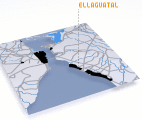 Places with similar names to El Laguatal, Venezuela ::
// Elkdale (US)
// Elkdale (US)
// Elkdale (US)
// El Cadillo (CO)
// El Guadual (CO)
// El Guadual (CO)
// El Cutal (SV)
// El Ocotal (SV)
// El Cadillo (MX)
// El Gatal (MX)
Disclaimer :: Information on this page comes without warranty of any kind |
||
|
Where is El Laguatal? Elevation and coordinates ::
Latitude (lat): 10°24'0"N Longitude (lon): 71°23'0"W
Elevation (approx.): 49m (map arrows pan, magnifying glasses zoom) |
||
|
Visiting El Laguatal? Hotel/Accommodation ::
Book a hotel in El Laguatal Travel Guide ::
Buy a travel guide for Venezuela rental cars ::
car rental offers GPS waypoint ::
download a GPX waypoint (PoI) of El Laguatal for your GPS receiver
|
||