|
search place name
|
||
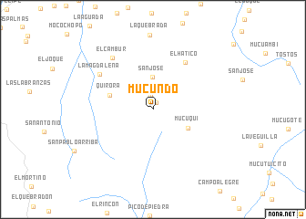
Mucundó (Mérida, Venezuela)Mucundó is a town in the Mérida region of Venezuela. An overview map of the region around Mucundó is displayed below.
regional and 3d topo map of Mucundó, Venezuela ::
Mucundó airports ::
The nearest airport is MRD - Merida Alberto Carnevalli, located 39.5 km north east of Mucundó.
Other airports nearby include STB - Santa Barbara Del Zulia (91.8 km north west), LFR - La Fria (94.7 km west), STD - Santo Domingo Mayor Buenaventura Vivas (108.7 km south west), SVZ - San Antonio Del Tachira (125.2 km south west), Nearby towns ::
La Ovejera (0.9km north east) //
Muchabá (1.8km north) //
San José (4.0km north) //
Mucuquí (4.8km south east) //
Quirorá (5.6km west) //
El Hatico (7.0km north east) //
La Magdalena (7.8km north west) //
El Cambur (8.0km north west) //
[all distances 'as the bird flies' and approximate] 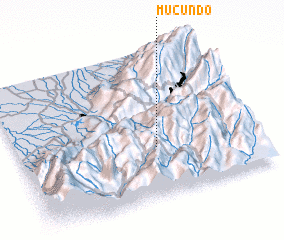 Places with similar names to Mucundó, Venezuela ::
Disclaimer :: Information on this page comes without warranty of any kind |
||
|
Where is Mucundó? Elevation and coordinates ::
Latitude (lat): 8°19'50"N Longitude (lon): 71°24'58"W
Elevation (approx.): 2476m (map arrows pan, magnifying glasses zoom) |
||
|
Visiting Mucundó? Hotel/Accommodation ::
Book a hotel in Mucundó Travel Guide ::
Buy a travel guide for Venezuela rental cars ::
car rental offers GPS waypoint ::
download a GPX waypoint (PoI) of Mucundó for your GPS receiver
|
||