|
search place name
|
||
Villa Marina (Falcón, Venezuela)Villa Marina is a town in the Falcón region of Venezuela. An overview map of the region around Villa Marina is displayed below.
regional and 3d topo map of Villa Marina, Venezuela ::
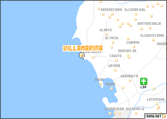
Villa Marina airports ::
The nearest airport is LSP - Paraguana Josefa Camejo, located 14.1 km east of Villa Marina.
Other airports nearby include CZE - Coro Jose Leonardo Chirinos (78.9 km south east), AUA - Oranjestad Reina Beatrix Intl (79.9 km north), CUR - Willemstad Hato (148.6 km east), MAR - Maracaibo La Chinita Intl (211.9 km south west), Nearby towns ::
Los Taques (2.2km east) //
Amuay (6.6km south east) //
Totubacoa (6.7km north east) //
Coduto (7.3km east) //
Jayana (7.4km east) //
El Hoyo (7.6km north east) //
El Tacal (7.6km north east) //
Adaro (9.0km south east) //
Judibana (10.8km south east) //
El Tacal (10.9km north east) //
San Antonio (11.8km north east) //
[all distances 'as the bird flies' and approximate] 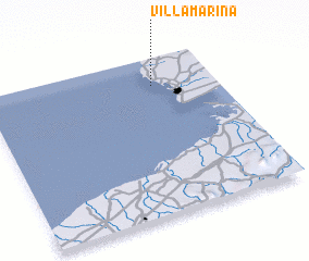 Places with similar names to Villa Marina, Venezuela ::
// Villamarín (ES)
// Volomborona (MG)
// Villa Marina (CO)
// Villa Moreno (CO)
// Valle Morín (VE)
// Villamorón (ES)
// Villemorien (FR)
// Villemorin (FR)
// Yvoy-le-Marron (FR)
// Villamarín (ES)
Disclaimer :: Information on this page comes without warranty of any kind |
||
|
Where is Villa Marina? Elevation and coordinates ::
Latitude (lat): 11°49'31"N Longitude (lon): 70°16'23"W
Elevation (approx.): 2m (map arrows pan, magnifying glasses zoom) |
||
|
Visiting Villa Marina? Hotel/Accommodation ::
Book a hotel in Villa Marina Travel Guide ::
Buy a travel guide for Venezuela rental cars ::
car rental offers GPS waypoint ::
download a GPX waypoint (PoI) of Villa Marina for your GPS receiver
|
||