|
search place name
|
||
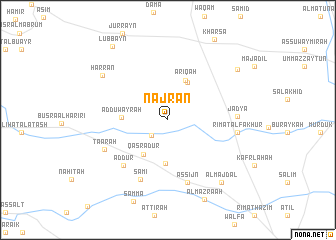
Najrān (As Suwaydāʼ, Syria)Najrān is a town in the As Suwaydāʼ region of Syria. An overview map of the region around Najrān is displayed below.
regional and 3d topo map of Najrān, Syria ::
Najrān airports ::
The nearest airport is OMF - Mafraq King Hussein, located 57.1 km south of Najrān.
Other airports nearby include DAM - Damascus Intl (62.9 km north), RPN - Rosh Pina Mahanaim I Ben Yaakov (83.2 km west), ADJ - Amman Marka Intl (105.9 km south west), HFA - Haifa (131.5 km west), Nearby towns ::
Qarrāşā (2.3km south west) //
‘Āhirah (4.5km north east) //
Qaşr ‘Adūr (4.5km south west) //
Riqqat aş Şaqr (4.8km south) //
‘Arīqah (4.7km north) //
Ad Duwayrah (4.4km west) //
‘Ad Dūr (6.6km south west) //
Samī‘ (7.1km south) //
As Sijn (7.2km south) //
Ta‘ārah (6.8km south west) //
Jadyā (6.6km east) //
Rīmat al Fakhūr (6.7km east) //
Ḩarrān (7.9km north west) //
Al Majdal (8.6km south east) //
Rasm Sibsābah (8.7km north east) //
Al Mazra‘ah (9.5km south) //
Lubbayn (9.7km north west) //
[all distances 'as the bird flies' and approximate]  Places with similar names to Najrān, Syria ::
Disclaimer :: Information on this page comes without warranty of any kind |
||
|
Where is Najrān? Elevation and coordinates ::
Latitude (lat): 32°50'46"N Longitude (lon): 36°26'48"E
Elevation (approx.): 770m (map arrows pan, magnifying glasses zoom) |
||
|
Visiting Najrān? Hotel/Accommodation ::
Book a hotel in Najrān Travel Guide ::
Buy a travel guide for Syria rental cars ::
car rental offers GPS waypoint ::
download a GPX waypoint (PoI) of Najrān for your GPS receiver
|
||