|
search place name
|
||
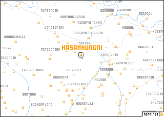
Hasamhŭng-ni (Yanggang, Korea, North)Hasamhŭng-ni is a town in the Yanggang region of Korea, North. An overview map of the region around Hasamhŭng-ni is displayed below.
regional and 3d topo map of Hasamhŭng-ni, Korea, North ::
Nearby towns ::
Samgong-ni (2.1km north west) //
Such'a-ri (2.5km north) //
Nongmang-ni (3.3km north west) //
Hŭgyŏn-ni (4.0km south) //
Indong-ni (3.2km east) //
Chung-ni (4.0km south east) //
Hadaebong-ni (4.2km north west) //
P'ungdŏng-ni (4.4km south east) //
Nongp'yŏngsang-ni (4.8km north) //
Hahamp'o (4.7km south east) //
Samsu-ŭp (4.5km east) //
Sinch'ŏl-li (4.8km east) //
Sŏngnae-ri (4.9km east) //
Sangdaebong-ni (5.6km north west) //
Koamp'oha-ri (6.7km south) //
Tongsu-ri (5.7km south east) //
T'aptong-ni (5.3km east) //
Koamp'osang-ni (7.0km south) //
Sŏdŏng-ni (6.4km south west) //
Pongdŏng-ni (5.4km west) //
Kwandong-ni (6.1km south east) //
Ch'oega-ri (6.1km north east) //
Nongp'yŏngha-ri (7.2km north) //
Samp'o-ri (6.8km south west) //
Sinhŭng-ni (5.6km west) //
Hach'on (6.9km south east) //
Wa-dong (7.1km south east) //
Suil-li (7.5km south) //
Ch'unbang-ni (6.6km north west) //
[all distances 'as the bird flies' and approximate]  Places with similar names to Hasamhŭng-ni, Korea, North :: Disclaimer :: Information on this page comes without warranty of any kind |
||
|
Where is Hasamhŭng-ni? Elevation and coordinates ::
Latitude (lat): 41°18'0"N Longitude (lon): 127°58'0"E
Elevation (approx.): 987m (map arrows pan, magnifying glasses zoom) |
||
|
Visiting Hasamhŭng-ni? Hotel/Accommodation ::
Book a hotel in Hasamhŭng-ni Travel Guide ::
rental cars ::
car rental offers GPS waypoint ::
download a GPX waypoint (PoI) of Hasamhŭng-ni for your GPS receiver
|
||