|
search place name
|
||
Kogaenŏmŏ-maŭl (Hamgyŏng, Korea, North)Kogaenŏmŏ-maŭl is a town in the Hamgyŏng region of Korea, North. An overview map of the region around Kogaenŏmŏ-maŭl is displayed below.
regional and 3d topo map of Kogaenŏmŏ-maŭl, Korea, North ::
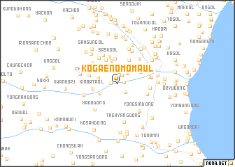
Nearby towns ::
Iamdongŏgu-ch'on (0.8km east) //
Araech'ŏngdŏk (0.8km west) //
Taehyangŏgu-ch'on (1.2km north) //
Taehyang-ni (1.4km north) //
Yangga-gol (1.8km north) //
Idŭksŏnggol (1.7km south east) //
Sae-mal (2.0km north) //
Taehyangdongha-ch'on (2.1km north east) //
Ha-ch'on (2.5km west) //
Utch'ŏngdŏk (2.7km south west) //
Nam-ch'on (3.6km north) //
Hwaha-ri (4.0km north) //
Kinbatpŏl (3.1km west) //
Tunjip'o (3.3km north east) //
Yŏugol (4.0km north) //
An'gol (4.0km north) //
Kuhyang (4.0km north) //
Tŏksan (3.7km north east) //
Sasu-gol (4.4km north) //
Chung-ch'on (3.7km west) //
Yŏnggang-dong (3.9km south east) //
Hwaam (4.8km north) //
Paenamu-gol (4.7km north west) //
Sagimak (4.5km north west) //
Sangjangdŏk (4.0km east) //
Ch'ŏngnyong-dong (3.9km east) //
P'yŏngdŏk (4.8km north east) //
Hapch'ŏn (4.6km north east) //
Hago-dong (5.0km south west) //
[all distances 'as the bird flies' and approximate] 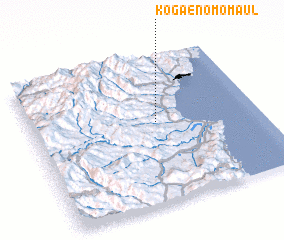 Places with similar names to Kogaenŏmŏ-maŭl, Korea, North :: Disclaimer :: Information on this page comes without warranty of any kind |
||
|
Where is Kogaenŏmŏ-maŭl? Elevation and coordinates ::
Latitude (lat): 41°33'0"N Longitude (lon): 129°33'0"E
Elevation (approx.): 129m (map arrows pan, magnifying glasses zoom) |
||
|
Visiting Kogaenŏmŏ-maŭl? Hotel/Accommodation ::
Book a hotel in Kogaenŏmŏ-maŭl Travel Guide ::
rental cars ::
car rental offers GPS waypoint ::
download a GPX waypoint (PoI) of Kogaenŏmŏ-maŭl for your GPS receiver
|
||