|
search place name
|
||
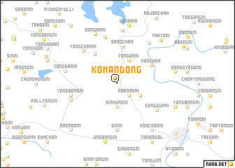
Kŏman-dong (Korea, North)Kŏman-dong is a town in Korea, North. An overview map of the region around Kŏman-dong is displayed below.
regional and 3d topo map of Kŏman-dong, Korea, North ::
Kŏman-dong airports ::
The nearest airport is FNJ - Pyongyang Intl, located 34.3 km south west of Kŏman-dong.
Other airports nearby include GMP - Seoul Gimpo (230.6 km south), Nearby towns ::
Naenam-ni (2.3km south east) //
Sinhŭng-ni (3.7km south) //
Yongam-ni (4.0km north) //
Chŏp-tong (3.4km south east) //
Ch'oe-gol (5.4km north west) //
Sangch'am (6.0km north) //
Kanch'am (5.1km north east) //
Sin-ni (7.4km south) //
Yongch'ŏn-ni (6.7km north west) //
Puam-ni (7.5km north) //
Yongbong-ni (6.0km west) //
Songgun-ni (6.5km south east) //
Kuryong-ni (6.2km south west) //
Kwangdo-ri (7.6km north east) //
Yongdam-ni (6.7km west) //
Yongwŏn-dong (8.5km north) //
Songam-ni (8.3km north) //
Kŭmch'ŏn-ni (8.6km south east) //
Tapto-ri (8.8km north east) //
Maenam-ni (9.4km south west) //
[all distances 'as the bird flies' and approximate]  Places with similar names to Kŏman-dong, Korea, North ::
// Camantang (PH)
// Kamunting (MY)
// Kammun-dong (KP)
// Kammun-dong (KP)
// Kamni-dong (KP)
// Koman-dong (KP)
// Kŏmun-dong (KP)
// Kŏmun-dong (KP)
// Kŏmun-dong (KP)
// Kŏmun-dong (KP)
Disclaimer :: Information on this page comes without warranty of any kind |
||
|
Where is Kŏman-dong? Elevation and coordinates ::
Latitude (lat): 39°30'0"N Longitude (lon): 125°51'0"E
Elevation (approx.): 84m (map arrows pan, magnifying glasses zoom) |
||
|
Visiting Kŏman-dong? Hotel/Accommodation ::
Book a hotel in Kŏman-dong Travel Guide ::
rental cars ::
car rental offers GPS waypoint ::
download a GPX waypoint (PoI) of Kŏman-dong for your GPS receiver
|
||