|
search place name
|
||
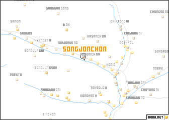
Songjŏn-ch'on (Hamgyŏng, Korea, North)Songjŏn-ch'on is a town in the Hamgyŏng region of Korea, North. An overview map of the region around Songjŏn-ch'on is displayed below.
regional and 3d topo map of Songjŏn-ch'on, Korea, North ::
Nearby towns ::
Hŭngni-ch'on (1.1km east) //
Yang-ch'on (2.4km north west) //
Sanghamjŏn (2.3km east) //
Hajungsan (3.7km south west) //
Sinjŏn-dong (3.8km north west) //
Hahamjŏn (3.6km south east) //
Yongp'yŏng (3.6km west) //
Kasan-ch'on (4.3km north east) //
Sinhŭng-ch'on (4.9km north) //
Indong-ni (4.0km north east) //
Kasan-ch'on (4.7km north east) //
Chunghŭng-ch'on (4.3km east) //
Korip (5.1km south east) //
Sagu (5.3km north west) //
Samgang-ch'on (5.5km east) //
Ch'ŏnp'yŏng (6.1km south east) //
Yŏngdae (6.3km south east) //
Samgi-ri (6.2km south east) //
Idŏk (7.4km north west) //
Tŏksalgu (7.8km south) //
Such'im (7.8km south) //
Indong-ni (6.3km east) //
Hŭllip-ch'on (6.3km east) //
Tokswalgwi (8.2km south) //
Sangnop'yŏng (7.3km south east) //
Sangil-li (6.9km north west) //
Sangjungsan (7.0km south west) //
Harop'yŏng (7.7km south east) //
Chungsŭngji (9.0km south) //
[all distances 'as the bird flies' and approximate]  Places with similar names to Songjŏn-ch'on, Korea, North ::
// Sangjŏnch'on (KR)
Disclaimer :: Information on this page comes without warranty of any kind |
||
|
Where is Songjŏn-ch'on? Elevation and coordinates ::
Latitude (lat): 40°28'21"N Longitude (lon): 128°13'8"E
Elevation (approx.): 283m (map arrows pan, magnifying glasses zoom) |
||
|
Visiting Songjŏn-ch'on? Hotel/Accommodation ::
Book a hotel in Songjŏn-ch'on Travel Guide ::
rental cars ::
car rental offers GPS waypoint ::
download a GPX waypoint (PoI) of Songjŏn-ch'on for your GPS receiver
|
||