|
search place name
|
||
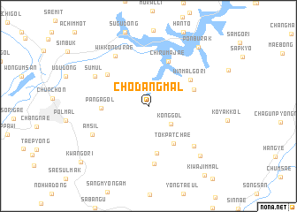
Ch'odang-mal (Kangwŏn, Korea, South)Ch'odang-mal is a town in the Kangwŏn region of Korea, South. An overview map of the region around Ch'odang-mal is displayed below.
regional and 3d topo map of Ch'odang-mal, Korea, South ::
Ch'odang-mal airports ::
The nearest airport is SHO - Sokch'o Sokcho, located 73.1 km north east of Ch'odang-mal.
Other airports nearby include SSN - Seoul East Seoul Ab (79.5 km south west), KAG - Kangnung Gangneung (97.7 km east), GMP - Seoul Gimpo (98.9 km west), OSN - Osan Ab (112.2 km south west), Nearby towns ::
Kong-gol (3.2km south east) //
Tŏkpatchae (5.4km south east) //
Panga-gol (4.7km west) //
Sarang-mal (6.0km south) //
K'ŭn'gŏ-ri (5.0km north east) //
Chirumajae (6.0km north) //
Winmalgŏri (5.4km north east) //
Nŭratchae (5.7km north west) //
Sarang-ch'on (7.4km south) //
Wikkŏndŭrae (7.1km north west) //
Sŭmul (6.5km north west) //
Sinnae (6.8km south east) //
Amsil (6.7km south west) //
Saet'ŏ (8.1km south east) //
Ponburak (9.0km north east) //
Kwan'gŏ-ri (9.8km south west) //
Kiwajim-mal (10.4km south east) //
[all distances 'as the bird flies' and approximate]  Places with similar names to Ch'odang-mal, Korea, South :: Disclaimer :: Information on this page comes without warranty of any kind |
||
|
Where is Ch'odang-mal? Elevation and coordinates ::
Latitude (lat): 37°51'58"N Longitude (lon): 127°50'37"E
Elevation (approx.): 231m (map arrows pan, magnifying glasses zoom) |
||
|
Visiting Ch'odang-mal? Hotel/Accommodation ::
Book a hotel in Ch'odang-mal Travel Guide ::
rental cars ::
car rental offers GPS waypoint ::
download a GPX waypoint (PoI) of Ch'odang-mal for your GPS receiver
|
||