|
search place name
|
||
Ban Saka (Laos)Ban Saka is a town in Laos. An overview map of the region around Ban Saka is displayed below.
regional and 3d topo map of Ban Saka, Laos ::

Ban Saka airports ::
The nearest airport is VTE - Vientiane Wattay Intl, located 48.1 km south of Ban Saka.
Other airports nearby include UTH - Udon Thani (118.8 km south), LOE - Loei (130.3 km south west), LPQ - Luang Prabang Luang Phabang Intl (167.9 km north), SNO - Sakon Nakhon (223.6 km south east), Nearby towns ::
Ban Noi (3.0km north east) //
Ban Na Kho (4.0km north east) //
Ban Deun Sai (4.1km north east) //
Ban Phon Than (5.6km south east) //
Ban Na Sang Noi (5.8km north east) //
Ban Namouang (9.3km north east) //
Ban Phônsoung (9.6km south east) //
[all distances 'as the bird flies' and approximate] 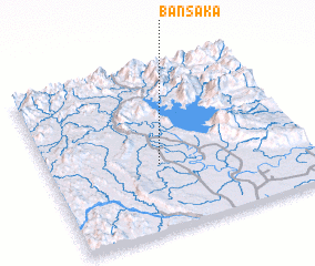 Places with similar names to Ban Saka, Laos ::
// Bansag (PH)
// Bünsche (DE)
// Ban Na Sak (TH)
// Ban Na Sok (TH)
// Ban Na Sok (TH)
// Ban Na Sok (TH)
// Ban Na Sok (TH)
// Ban Sa Kae (TH)
// Ban Sakae (TH)
// Ban Sakae (TH)
Disclaimer :: Information on this page comes without warranty of any kind |
||
|
Where is Ban Saka? Elevation and coordinates ::
Latitude (lat): 18°24'10"N Longitude (lon): 102°25'40"E
Elevation (approx.): 177m (map arrows pan, magnifying glasses zoom) |
||
|
Visiting Ban Saka? Hotel/Accommodation ::
Book a hotel in Ban Saka Travel Guide ::
Buy a travel guide for Laos rental cars ::
car rental offers GPS waypoint ::
download a GPX waypoint (PoI) of Ban Saka for your GPS receiver
|
||