|
search place name
|
||
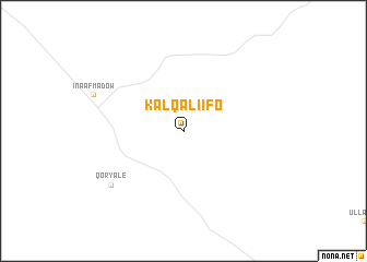
Kal Qaliifo (Togdheer, Somalia)Kal Qaliifo is a town in the Togdheer region of Somalia. An overview map of the region around Kal Qaliifo is displayed below.
regional and 3d topo map of Kal Qaliifo, Somalia ::
Kal Qaliifo airports ::
The nearest airport is BBO - Berbera, located 184.9 km north west of Kal Qaliifo.
Other airports nearby include HGA - Hargeisa Egal Intl (218.2 km west), Nearby towns ::
Qoryale (9.2km south west) //
[all distances 'as the bird flies' and approximate]  Places with similar names to Kal Qaliifo, Somalia ::
// Qılqlov (AZ)
// Colle Calvo (IT)
// Gologlovo (BA)
// Gola Glava (BG)
// Glagolevo (RU)
// Kelkolovo (RU)
// Klukolovo (RU)
// Kolokolovo (RU)
// Kalokolevu (FJ)
// Kolokolovo (RU)
Disclaimer :: Information on this page comes without warranty of any kind |
||
|
Where is Kal Qaliifo? Elevation and coordinates ::
Latitude (lat): 9°7'0"N Longitude (lon): 46°2'0"E
Elevation (approx.): 910m (map arrows pan, magnifying glasses zoom) |
||
|
Visiting Kal Qaliifo? Hotel/Accommodation ::
Book a hotel in Kal Qaliifo Travel Guide ::
Buy a travel guide for Somalia rental cars ::
car rental offers GPS waypoint ::
download a GPX waypoint (PoI) of Kal Qaliifo for your GPS receiver
|
||