|
search place name
|
||
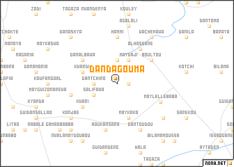
Dan Dagouma (Maradi, Niger)Dan Dagouma is a town in the Maradi region of Niger. An overview map of the region around Dan Dagouma is displayed below.
regional and 3d topo map of Dan Dagouma, Niger ::
Dan Dagouma airports ::
The nearest airport is MFG - Maradi, located 94.4 km south west of Dan Dagouma.
Other airports nearby include ZND - Zinder (135.8 km east), QUS - Gusau (241.2 km south west), Nearby towns ::
Guidan Bogwari (1.8km east) //
Dan Tchiro (3.6km west) //
Kyassara (3.7km north) //
Salifawa (4.0km south west) //
May Daji (4.1km north east) //
Maykaka (5.8km south) //
Kwarda (5.7km west) //
Kwari (6.5km south west) //
Al Hassane (6.6km north east) //
Dan Albawa (6.5km north west) //
Boultou (6.5km north east) //
Hammi (7.4km north) //
Mayléllé Baba (7.3km south east) //
Aoukansara (7.6km south) //
Halbaou (7.4km west) //
Dan Toudou (8.2km south east) //
Mayléllé Karama (9.1km south east) //
Kanjaé (9.1km south west) //
Wachémawa (9.2km north east) //
Takassaba (9.2km north east) //
Abiggui (10.3km south west) //
Dan Askya (10.3km north west) //
[all distances 'as the bird flies' and approximate]  Places with similar names to Dan Dagouma, Niger ::
// Tondokumbo (ID)
// Dandugama (LK)
// Tondi Gamey (NE)
// Tondi Gamey (NE)
// Tondigamé (ML)
// Tondigamé (ML)
// Tendagum (PG)
// Tendokom (SL)
// Tendokom (SL)
// Tendokom (SL)
Disclaimer :: Information on this page comes without warranty of any kind |
||
|
Where is Dan Dagouma? Elevation and coordinates ::
Latitude (lat): 14°5'0"N Longitude (lon): 7°46'0"E
Elevation (approx.): 396m (map arrows pan, magnifying glasses zoom) |
||
|
Visiting Dan Dagouma? Hotel/Accommodation ::
Book a hotel in Dan Dagouma Travel Guide ::
Buy a travel guide for Niger rental cars ::
car rental offers GPS waypoint ::
download a GPX waypoint (PoI) of Dan Dagouma for your GPS receiver
|
||