|
search place name
|
||
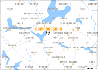
Garin Bassako (Zinder, Niger)Garin Bassako is a town in the Zinder region of Niger. An overview map of the region around Garin Bassako is displayed below.
regional and 3d topo map of Garin Bassako, Niger ::
Garin Bassako airports ::
The nearest airport is ZND - Zinder, located 112.2 km south of Garin Bassako.
Other airports nearby include MFG - Maradi (224.2 km south west), Nearby towns ::
Kirikawa (2.6km north east) //
Garin Boka (3.6km east) //
Maytsiga (4.0km south east) //
Katchan Katchan (4.1km north west) //
Zérmou (5.2km south west) //
Dan Kanassa (5.2km south east) //
Gobérawa (5.6km south) //
Zoui (5.8km north) //
Guidan Toudou (5.8km north) //
Tountafi (7.4km south) //
Mouchéri (7.2km east) //
Guijikawa (7.4km west) //
Ganjinwa (7.7km north west) //
Zabéwa (7.7km north east) //
Chakala (7.7km south east) //
May Diga (8.2km north west) //
Tchinbouaragan (8.1km north east) //
Kadéri (9.2km south west) //
Majia (9.1km south east) //
Garin Algo (9.1km south east) //
Sourounya (10.3km north west) //
[all distances 'as the bird flies' and approximate] 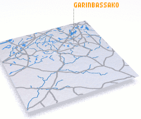 Places with similar names to Garin Bassako, Niger ::
// Grünbusch (DE)
Disclaimer :: Information on this page comes without warranty of any kind |
||
|
Where is Garin Bassako? Elevation and coordinates ::
Latitude (lat): 14°46'0"N Longitude (lon): 8°45'0"E
Elevation (approx.): 506m (map arrows pan, magnifying glasses zoom) |
||
|
Visiting Garin Bassako? Hotel/Accommodation ::
Book a hotel in Garin Bassako Travel Guide ::
Buy a travel guide for Niger rental cars ::
car rental offers GPS waypoint ::
download a GPX waypoint (PoI) of Garin Bassako for your GPS receiver
|
||