|
search place name
|
||
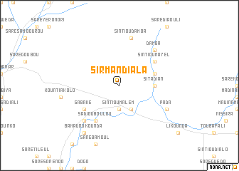
Sirman Diala (Tambacounda, Senegal)Sirman Diala is a town in the Tambacounda region of Senegal. An overview map of the region around Sirman Diala is displayed below.
regional and 3d topo map of Sirman Diala, Senegal ::
Sirman Diala airports ::
The nearest airport is TUD - Tambacounda, located 31.1 km south east of Sirman Diala.
Other airports nearby include BXE - Bakel (191.3 km north east), KGG - Kedougou (231.9 km south east), SEY - Selibabi Selibady (235.8 km north east), BXO - Bissau Oswaldo Vieira Intl (286.9 km south west), Nearby towns ::
Sintiou Malèm (3.7km south) //
Girigara (4.1km south east) //
Saré Ouri (5.4km east) //
Sitadian (5.4km east) //
Sintiou Dialégué (5.4km east) //
Saré Faré (5.7km east) //
Sadiou Boulou (6.6km south west) //
Sabaké (6.5km south west) //
Sintiou Mâyél (6.5km north east) //
Sintiou Damba (7.6km north) //
Madina Diaka (7.7km south west) //
Damba (7.7km north east) //
Pada (8.1km south east) //
Bamadoukounda (9.2km south west) //
[all distances 'as the bird flies' and approximate] 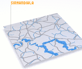 Places with similar names to Sirman Diala, Senegal ::
Disclaimer :: Information on this page comes without warranty of any kind |
||
|
Where is Sirman Diala? Elevation and coordinates ::
Latitude (lat): 13°51'0"N Longitude (lon): 13°55'0"W
Elevation (approx.): 29m (map arrows pan, magnifying glasses zoom) |
||
|
Visiting Sirman Diala? Hotel/Accommodation ::
Book a hotel in Sirman Diala Travel Guide ::
Buy a travel guide for Senegal rental cars ::
car rental offers GPS waypoint ::
download a GPX waypoint (PoI) of Sirman Diala for your GPS receiver
|
||