|
search place name
|
||
Aḑ Ḑarb (Al Jumaylīyah, Qatar)Aḑ Ḑarb is a town in the Al Jumaylīyah region of Qatar. An overview map of the region around Aḑ Ḑarb is displayed below.
regional and 3d topo map of Aḑ Ḑarb, Qatar ::

Aḑ Ḑarb airports ::
The nearest airport is DOH - Doha Intl, located 67.8 km east of Aḑ Ḑarb.
Other airports nearby include BAH - Bahrain Intl (95.4 km north), DHA - Dhahran King Abdulaziz Ab (118.9 km north west), LEA - Al-ahsa Al Ahsa (146.1 km west), DMM - Dammam King Fahd Intl (159.7 km north west), Nearby towns ::
Khawzān (3.5km north east) //
Al ‘Uwaynah (3.4km east) //
Umm al Quhāb ‘Abd Allāh Bin Nāşir (6.3km north east) //
Umm al Quhāb al ‘Atīq (7.8km north east) //
Biʼr Zikrīt (9.2km north west) //
[all distances 'as the bird flies' and approximate] 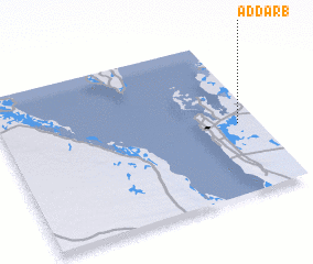 Places with similar names to Aḑ Ḑarb, Qatar ::
// Aţrab (IR)
// Adderabi (TD)
// Ad Darb (SA)
// Ad Darb (SA)
// Ad Darb (SA)
// Ataraba (NE)
// At Turbah (SY)
// At Turbah (YE)
// Aït Ouarab (MA)
// At Tarbī‘ah (LB)
Disclaimer :: Information on this page comes without warranty of any kind |
||
|
Where is Aḑ Ḑarb? Elevation and coordinates ::
Latitude (lat): 25°27'5"N Longitude (lon): 50°55'30"E
Elevation (approx.): 2m (map arrows pan, magnifying glasses zoom) |
||
|
Visiting Aḑ Ḑarb? Hotel/Accommodation ::
Book a hotel in Aḑ Ḑarb Travel Guide ::
Buy a travel guide for Qatar rental cars ::
car rental offers GPS waypoint ::
download a GPX waypoint (PoI) of Aḑ Ḑarb for your GPS receiver
|
||