|
search place name
|
||
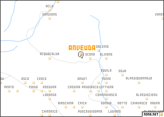
Anvéuda (Aargau, Switzerland)Anvéuda is a town in the Aargau region of Switzerland. An overview map of the region around Anvéuda is displayed below.
regional and 3d topo map of Anvéuda, Switzerland ::
Anvéuda airports ::
The nearest airport is LUG - Lugano, located 58.8 km south of Anvéuda.
Other airports nearby include SMV - Samedan (75.5 km east), MXP - Milano Malpensa (101.2 km south), ZRH - Zurich (106.9 km north), BGY - Bergamo Orio Al Serio (114.0 km south east), Nearby towns ::
Scona (1.3km east) //
Campo Blenio (3.2km north east) //
Olivone (3.8km east) //
Ardet (5.6km south) //
Aquila (5.3km south east) //
Ponto Valentino (6.1km south east) //
Castro (6.1km south east) //
Acquacalda (5.1km west) //
Prugiasco (7.5km south) //
Cassina (7.5km south) //
Torre (6.7km south east) //
Negrentino (7.8km south) //
Lottigna (8.3km south east) //
Rossura (9.0km south west) //
[all distances 'as the bird flies' and approximate] 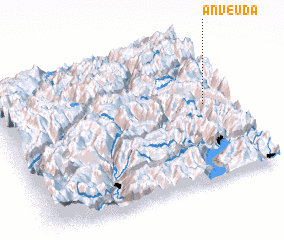 Places with similar names to Anvéuda, Switzerland ::
// Anefid (MA)
// Anfoud (MA)
// Ānavatti (IN)
// Anghad (IN)
// Anfetu (GH)
// Anaghd (MA)
// ‘Ayn Fīt (SY)
// An Phú Tây (VN)
// An Phú Tây (VN)
// Anaghit (ER)
Disclaimer :: Information on this page comes without warranty of any kind |
||
|
Where is Anvéuda? Elevation and coordinates ::
Latitude (lat): 46°32'0"N Longitude (lon): 8°54'0"E
Elevation (approx.): 1517m (map arrows pan, magnifying glasses zoom) |
||
|
Visiting Anvéuda? Hotel/Accommodation ::
Book a hotel in Anvéuda Travel Guide ::
Buy a travel guide for Switzerland rental cars ::
car rental offers GPS waypoint ::
download a GPX waypoint (PoI) of Anvéuda for your GPS receiver
|
||