|
search place name
|
||
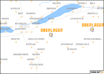
Ober Läger (Aargau, Switzerland)Ober Läger is a town in the Aargau region of Switzerland. An overview map of the region around Ober Läger is displayed below.
regional and 3d topo map of Ober Läger, Switzerland ::
Ober Läger airports ::
The nearest airport is BRN - Bern Belp, located 45.4 km north west of Ober Läger.
Other airports nearby include SIR - Sion (67.7 km south west), ZRH - Zurich (101.4 km north east), LUG - Lugano (103.1 km south east), MLH - Bale Mulhouse (109.2 km north), Nearby towns ::
Lütschenthal (2.2km south west) //
Iseltwald (5.6km north) //
Sengg (5.6km north) //
Zweilütschinen (4.2km south west) //
Unter Eiger (5.3km south east) //
Wengen (6.1km south west) //
Bönigen (5.3km north west) //
Gsteig (5.4km west) //
Lauterbrunnen (6.7km south west) //
Ringgenberg (6.7km north west) //
Isenfluh (6.3km south west) //
Niederried (7.8km north) //
Alpiglen (7.5km south east) //
Buchen (8.3km south west) //
Goldswil (7.5km north west) //
Schwendi (9.0km north west) //
[all distances 'as the bird flies' and approximate] 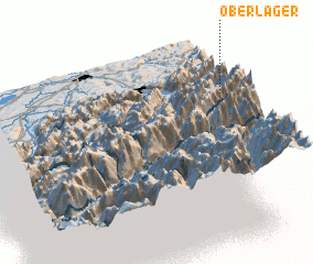 Places with similar names to Ober Läger, Switzerland ::
// Oberläger (CH)
Disclaimer :: Information on this page comes without warranty of any kind |
||
|
Where is Ober Läger? Elevation and coordinates ::
Latitude (lat): 46°39'0"N Longitude (lon): 7°57'0"E
Elevation (approx.): 1617m (map arrows pan, magnifying glasses zoom) |
||
|
Visiting Ober Läger? Hotel/Accommodation ::
Book a hotel in Ober Läger Travel Guide ::
Buy a travel guide for Switzerland rental cars ::
car rental offers GPS waypoint ::
download a GPX waypoint (PoI) of Ober Läger for your GPS receiver
|
||