|
search place name
|
||
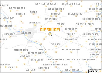
Gieshügel (Bayern, Germany)Gieshügel is a town in the Bayern region of Germany. An overview map of the region around Gieshügel is displayed below.
regional and 3d topo map of Gieshügel, Germany ::
Gieshügel airports ::
The nearest airport is GHF - Giebelstadt Aaf, located 15.5 km south of Gieshügel.
Other airports nearby include NUE - Nuernberg Nurnberg (82.2 km east), ZNF - Hanau Aaf (87.0 km north west), FRA - Frankfurt Main (109.3 km west), MHG - Mannheim City (113.9 km west), Nearby towns ::
Wöllriederhof (1.2km west) //
Rottendorf (2.2km north east) //
Gerbrunn (1.9km south west) //
Theilheim (3.9km south) //
Randersacker (3.6km south west) //
Rothof (4.4km north east) //
Lengfeld (4.4km north west) //
Estenfeld (5.6km north) //
Heidingsfeld (4.0km south west) //
Lindelbach (5.7km south) //
Eibelstadt (5.7km south) //
Westheim (5.2km south east) //
Versbach (5.8km north west) //
Neuhof (4.8km east) //
Mühlhausen (7.4km north) //
Biebelried (5.1km east) //
Effeldorf (5.1km east) //
Kürnach (7.5km north) //
Maidbronn (7.7km north west) //
Rottenbauer (7.8km south west) //
Kaltensondheim (7.3km south east) //
Rimpar (9.1km north west) //
[all distances 'as the bird flies' and approximate]  Places with similar names to Gieshügel, Germany :: Disclaimer :: Information on this page comes without warranty of any kind |
||
|
Where is Gieshügel? Elevation and coordinates ::
Latitude (lat): 49°47'0"N Longitude (lon): 10°1'0"E
Elevation (approx.): 259m (map arrows pan, magnifying glasses zoom) |
||
|
Visiting Gieshügel? Hotel/Accommodation ::
Book a hotel in Gieshügel Travel Guide ::
Buy a travel guide for Germany rental cars ::
car rental offers GPS waypoint ::
download a GPX waypoint (PoI) of Gieshügel for your GPS receiver
|
||