|
search place name
|
||
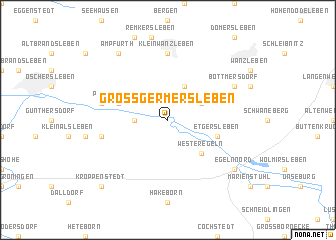
Groß Germersleben (Sachsen-Anhalt, Germany)Groß Germersleben is a town in the Sachsen-Anhalt region of Germany. An overview map of the region around Groß Germersleben is displayed below.
regional and 3d topo map of Groß Germersleben, Germany ::
Groß Germersleben airports ::
The nearest airport is BWE - Braunschweig Wolfsburg, located 65.9 km north west of Groß Germersleben.
Other airports nearby include LEJ - Leipzig Halle (87.4 km south east), ZCN - Celle (112.9 km north west), ERF - Erfurt (117.0 km south), HAJ - Hannover (125.8 km north west), Nearby towns ::
Klein Oschersleben (2.3km west) //
Stadt Frankfurt (3.9km north) //
Klein Germersleben (2.9km north east) //
Westeregeln (4.4km south east) //
Peseckendorf (3.9km north west) //
Etgersleben (3.9km south east) //
Klein Wanzleben (7.4km north) //
Hadmersleben (4.9km west) //
Andersleben (4.9km west) //
Bottmersdorf (5.9km north east) //
Egeln Nord (7.2km south east) //
Egeln (7.2km south east) //
Ampfurth (8.2km north west) //
Kroppenstedt (8.7km south west) //
[all distances 'as the bird flies' and approximate] 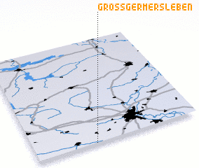 Places with similar names to Groß Germersleben, Germany :: Disclaimer :: Information on this page comes without warranty of any kind |
||
|
Where is Groß Germersleben? Elevation and coordinates ::
Latitude (lat): 52°0'0"N Longitude (lon): 11°22'0"E
Elevation (approx.): 75m (map arrows pan, magnifying glasses zoom) |
||
|
Visiting Groß Germersleben? Hotel/Accommodation ::
Book a hotel in Groß Germersleben Travel Guide ::
Buy a travel guide for Germany rental cars ::
car rental offers GPS waypoint ::
download a GPX waypoint (PoI) of Groß Germersleben for your GPS receiver
|
||