|
search place name
|
||
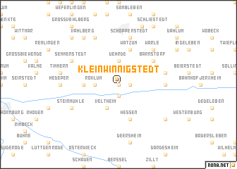
Klein Winnigstedt (Niedersachsen, Germany)Klein Winnigstedt is a town in the Niedersachsen region of Germany. An overview map of the region around Klein Winnigstedt is displayed below.
regional and 3d topo map of Klein Winnigstedt, Germany ::
Klein Winnigstedt airports ::
The nearest airport is BWE - Braunschweig Wolfsburg, located 31.6 km north west of Klein Winnigstedt.
Other airports nearby include ZCN - Celle (77.3 km north west), HAJ - Hannover (85.9 km north west), KSF - Kassel Calden (120.7 km south west), ERF - Erfurt (121.6 km south), Nearby towns ::
Winnigstedt (0.0km north) //
Groß Winnigstedt (1.1km east) //
Mattierzoll (1.9km south) //
Uehrde (3.7km north) //
Roklum (2.3km west) //
Veltheim (3.9km south) //
Wetzleben (3.4km west) //
Hessen (5.7km south) //
Watzum (5.7km north) //
Barnstorf (5.0km north east) //
Gevensleben (4.6km east) //
Schöppenstedt (7.5km north) //
Watenstedt (4.9km east) //
Warle (6.5km north east) //
Berklingen (7.8km north) //
Semmenstedt (5.9km north west) //
Steinmühle (5.9km south west) //
Rohrsheim (7.2km south east) //
Vahlberg (8.2km north west) //
Klein Vahlberg (8.7km north west) //
[all distances 'as the bird flies' and approximate] 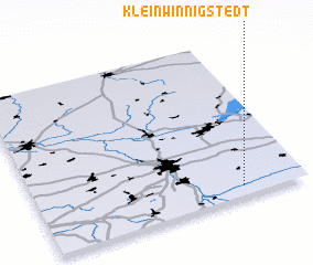 Places with similar names to Klein Winnigstedt, Germany :: Disclaimer :: Information on this page comes without warranty of any kind |
||
|
Where is Klein Winnigstedt? Elevation and coordinates ::
Latitude (lat): 52°4'0"N Longitude (lon): 10°46'0"E
Elevation (approx.): 94m (map arrows pan, magnifying glasses zoom) |
||
|
Visiting Klein Winnigstedt? Hotel/Accommodation ::
Book a hotel in Klein Winnigstedt Travel Guide ::
Buy a travel guide for Germany rental cars ::
car rental offers GPS waypoint ::
download a GPX waypoint (PoI) of Klein Winnigstedt for your GPS receiver
|
||