|
search place name
|
||
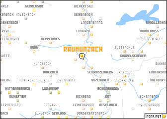
Raumünzach (Baden-Württemberg, Germany)Raumünzach is a town in the Baden-Württemberg region of Germany. An overview map of the region around Raumünzach is displayed below.
regional and 3d topo map of Raumünzach, Germany ::
Raumünzach airports ::
The nearest airport is ZCC - Baden-baden Baden Oos, located 21.3 km north west of Raumünzach.
Other airports nearby include SXB - Strassbourg Entzheim (54.3 km west), STR - Stuttgart (64.5 km east), ZQL - Donaueschingen Villingen (74.5 km south), ZQC - Speyer (74.8 km north), Nearby towns ::
Kirschbaumwasen (1.9km south) //
Poppeltal (1.9km south) //
Erbersbronn (1.2km west) //
Schönmünzach (2.2km south east) //
Schwarzenberg (4.4km south east) //
Bermersbach (5.6km north) //
Forbach (5.6km north) //
Gausbach (5.7km north) //
Zwickgabel (6.1km south west) //
Huzenbach (6.1km south east) //
Langenbrand (7.5km north) //
Biberach (6.1km south west) //
Herrenwies (6.1km north west) //
Grafenberg (8.3km south west) //
Schönegründ (8.3km south east) //
Mittellangenbach (7.4km south west) //
Besenfeld (7.4km south east) //
Lindenhof (8.9km south west) //
[all distances 'as the bird flies' and approximate]  Places with similar names to Raumünzach, Germany :: Disclaimer :: Information on this page comes without warranty of any kind |
||
|
Where is Raumünzach? Elevation and coordinates ::
Latitude (lat): 48°38'0"N Longitude (lon): 8°21'0"E
Elevation (approx.): 613m (map arrows pan, magnifying glasses zoom) |
||
|
Visiting Raumünzach? Hotel/Accommodation ::
Book a hotel in Raumünzach Travel Guide ::
Buy a travel guide for Germany rental cars ::
car rental offers GPS waypoint ::
download a GPX waypoint (PoI) of Raumünzach for your GPS receiver
|
||